- Current Cascade Range Seismic Activity Information
- Cascade Range Current Activity Updates — includes Seismic information
- Pacific Northwest Seismic Network — Information, maps, includes link to the University of Washington “Real-Time” seismic information
- Background and Information
- Earthquake Terminology
-
DESCRIPTION: Earthquakes and Seismicity — Amplitudes … Earthquake … Earthquake Swarms … Harmonic Tremor … Intensity … “Lg” Waves … Local Magnitude Scale … Long Period Earthquakes … Love Waves … Magnitude … Mercalli Scale … “P” Waves … Primary Waves … Rayleigh Waves … Richter Scale … Rossi-Forel Scale … “S” Waves … Secondary Waves … Shear Waves … Seismic Amplitudes … Seismic Waves … Shallow Earthquakes … Short Period Earthquakes … Surface Events … Surface Waves … Tectonic Earthquakes … Tremor … Volcanic Earthquakes … Volcanic Tremor …
- Special Items of Interest
- What Causes Earthquakes? — Excerpt from: Noson, Qamar, and Thorsen, 1988
- Cascade Range Seismicity Menus
- Monitoring Information
-
DESCRIPTION: Seismometers, Seismographs, and Seismograms, etc. — Accelerograph … Broad Band Seismic Station … Seismogram … Seismograph … Seismograph Station … Seismologist … Seismometry … Short Period Seismic Station … Strong Motion Seismic Station …
- DESCRIPTION: RSAM (Real-Time Seismic-Amplitude) Systems and SSAM (Seismic Signal-Amplitude) Systems
- Monitoring Techniques – Menu
-
- Maps, Graphics, and Images
- Maps and Graphics – Earthquakes and Seismicity
- CVO Photo Archives – Monitoring Images, 1980-2004 — includes Seismic
- CVO Photo Archives – Monitoring Images, 2004 to Current — includes Seismic
- Publications and Reports
- Items of Interest
- Adams (Mount Adams) Earthquakes and Seismicity – Menu
-
Approximate event counts, by event type at five Cascade volcanoes, 1989-90. — includes Mount Baker, Mount Rainier, Mount St. Helens, Mount Adams, and Mount Hood — Jonientz-Trisler, Myers, and Power, 1994, IN: USGS Bulletin 2047
- Baker (Mount Baker) Earthquakes and Seismicity – Menu
- Cascade Range – Current Activity Updates — includes Seismic information
- Cascade Range Earthquakes and Seismicity – Description
- Cascade Range Earthquakes and Seismicity – Menu
- Crater Lake Earthquakes and Seismicity – Menu
- DESCRIPTION: Cascade Range Earthquakes and Seismicity
- DESCRIPTION: Earthquakes and Seismicity
- DESCRIPTION: RSAM (Real-Time Seismic-Amplitude) Systems and SSAM (Seismic Signal-Amplitude) Systems
- DESCRIPTION: Seismometers, Seismographs, and Seismograms, etc.
- Earthquake Terminology
- Earthquakes and Seismicity, Signals and Tremor, Magnitude and Intensity – Description
- Earthquake Swarms – Description
- Glacier Peak Earthquakes and Seismicity – Menu
- Harmonic Tremor – Description
- Hazards: Seismicity — Excerpt from: Hoblitt, et.al., 1987, USGS Open-File Report 87-297
- Hood (Mount Hood) Earthquakes and Seismicity – Menu
- Magnitudes and Intensity – Description
- Maps and Graphics – Earthquakes and Seismicity
- Modified Mercalli Intensity Scale – Description
- Monitoring Techniques – Menu
- Mount Adams Earthquakes and Seismicity – Menu
- Mount Baker Earthquakes and Seismicity – Menu
- Mount Hood Earthquakes and Seismicity – Menu
- Mount Hood – July 1980 Mt. Hood earthquake swarm — Rite and Iyer, 1981, USGS Open-File Report 81-48
- Mount Rainier Earthquakes and Seismicity – Menu
- Mount St. Helens Earthquakes and Seismicity – Menu
- Mount St. Helens May 18, 1980 Seismogram — [Graphic,561K,InlineJpg]
- Oregon Cascades Earthquakes and Seismicity – Description
-
Pacific Northwest Seismograph Network — information, maps, and links to the University of Washington Geophysic Programs Pacific Northwest Seismic Network Website
- CVO Photo Archives – Monitoring Images, 1980-2004 — includes Seismic
- CVO Photo Archives – Monitoring Images, 2004 to Current — includes Seismic
- Plate Tectonics – Menu — general information about plate tectonics
- Publications and Reports – Earthquakes and Seismicity
- Rainier (Mount Rainier) Earthquakes and Seismicity – Menu
- Richter Scale – Local Magnitude Scale – Moment Magnitude Scale – Description
- RSAM (Real-Time Seismic-Amplitude) Systems – Description
-
Seismic Monitoring at Cascade Volcanic Centers, 2004 — Status and Recommendations — Moran, 2005, USGS Scientific Investigations Report 2004-5211
-
Seismic studies at the Mt. Hood Volcano, northern Cascade Range, Oregon — Green, et.al., 1979, USGS Open-File Report 79-1261
- Seismic Waves – Description
- Seismicity – Cascade Range – Menu
- Seismometers, Seismographs, and Seismograms, etc. – Description
- SSAM (Seismic Spectral-Amplitude) Systems – Description
- St. Helens (Mount St. Helens) Earthquakes and Seismicity – Menu
- Terminology — Earthquake and Seismic, etc. Terminology
- Three Sisters Earthquakes and Seismicity – Menu
- Tsunami and Seismic Sea Waves – Menu
- Volcano and Hydrologic Hazards – Menu
- Volcano and Hydrologic Monitoring – Menu
- VolQuake Program
- Washington Cascades Earthquakes and Seismicity – Description
-
What Causes Earthquakes? — Excerpt from: Noson, Qamar, and Thorsen, 1988, Washington State Earthquake Hazards
- Useful Links
-
Washington State Earthquake Hazards — Noson, et.al., 1988, Washington Division of Geology and Earth Resources Information Circular 85, link courtesy University of Washington Geophysics Program
-
- Other Menus of Interest
- Cascade Range Earthquakes and Seismicity — CVO Menu
- Volcano and Hydrologic Hazards Menu — CVO Menu
- Volcano and Hydrologic Monitoring Menu — CVO Menu
- Volcano and Hydrologic Projects and Research Menu — CVO Menu
URL for this page is: <http://vulcan.wr.usgs.gov/Glossary/Seismicity/framework.html>
If you have questions or comments please contact: <GS-CVO-WEB@usgs.gov>
04/27/07, Lyn Topinka
URL for this page is: <http://vulcan.wr.usgs.gov/Glossary/framework.html>
If you have questions or comments please contact: <GS-CVO-WEB@usgs.gov>
01/30/03, Lyn Topinka
- Accelerograph:
- A seismograph whose output is proportional to ground acceleration (in comparison to the usual seismograph whose output is proportional to ground velocity). Accelerographs are typically used as instruments designed to record very strong ground motion useful in engineering design; seismographs commonly record off scale in these circumstances. Normally, strong motion instruments do not record unless triggered by strong ground motion.(Noson, et.al., 1988)
- Aftershock:
- One of many earthquakes that often occur during the days to months after some larger earthquake (mainshock) has occurred. Aftershocks occur in the same general region as the mainshock and are believed to be the result of minor readjustments of stress at places in the fault zone.(Noson, et.al., 1988)
- An earthquake which follows a larger earthquake or main shock and originates in or near the rupture zone of the larger earthquake. Generally, major earthquakes are followed by a larger number of aftershocks, decreasing in frequency with time.(USGS National Earthquake Information Center, 1999)
- Amplitude:
- The amplitude of a seismic wave is the amount the ground moves as the wave passes by. (As an illustration, the amplitude of an ocean wave is one-half the distance between the peak and trough of the wave. The amplitude of a seismic wave can be measured from the signal recorded on a seismogram.)(Noson, et.al., 1988)
- The maximum height of a wave crest of depth of a trough.(USGS National Earthquake Information Center, 1999)
- Broad Band Seismic Station:
- Crust:
- The Earth’s outermost layer.(Teacher’s Packet)
- Deep Earthquakes:
- …deep earthquakes and those located away from the volcano, which produce high-frequency signatures and sharp arrivals similar to tectonic earthquakes(Brantley and Topinka, 1984)
- Earthquake:
- Shaking of the Earth caused by a sudden movement of rock beneath its surface.(USGS National Earthquake Information Center, 1999)
- The release of stored elastic energy caused by sudden fracture and movement of rocks inside the Earth. Part of the energy released produces seismic waves, like P, S, and surface waves, that travel outward in all directions from the point of initial rupture. These waves shake the ground as they pass by. An earthquake is felt if the shaking is strong enough to cause ground accelerations exceeding approximately 1.0 centimeter/second squared.(Noson, et.al., 1988)
- Earthquake swarm:
- A series of minor earthquakes, none of which may be identified as the main shock, occurring in a limited area and time.(USGS National Earthquake Information Center, 1999)
- Epicenter:
- That point on the Earth’s surface directly above the hypocenter of an earthquake.(USGS National Earthquake Information Center, 1999)
- The location on the surface of the Earth directly above the focus, or place where an earthquake originates. An earthquake caused by a fault that offsets features on the Earth’s surface may have an epicenter that does not lie on the trace of that fault on the surface. This occurs if the fault plane is not vertical and the earthquake occurs below the Earth’s surface.(Noson, et.al., 1988)
- Fault:
- A break in the Earth along which movement occurs. Sudden movement along a fault produces earthquakes. Slow movement produces aseismic creep.(Noson, et.al., 1988)
- Focus:
- That point within the Earth from which originates the first motion of an earthquake and its elastic waves.(USGS National Earthquake Information Center, 1999)
- Foreshock:
- A small tremor that commonly precedes a larger earthquake or main shock by seconds to weeks and that originates in or near the rupture zone of the larger earthquake.(USGS National Earthquake Information Center, 1999)
- Harmonic tremor:
- Continuous rhythmic earthquakes in the Earth’s upper lithosphere that can be detected by seimographs. Harmonic tremors often precede or accompany volcanic eruptions.(Teacher’s Packet)
- A continuous release of seismic energy typically associated with the underground movement of magma. It contrasts distinctly with the sudden release and rapid decrease of seismic energy associated with the more common type of earthquake caused by slippage along a fault.(Foxworthy and Hill, 1982)
- … harmonic tremor, which is a long-lasting, very rhythmic signal whose origin is not well understood but which is often associated with active volcanoes …(Brantley and Topinka, 1984)
- Hypocenter:
- The calculated location of the focus of an earthquake.(USGS National Earthquake Information Center, 1999)
- Intensity:
- A measure of severity of shaking at a particular site. It is usually estimated from descriptions of damage to buildings and terrain. The intensity is often greatest near the earthquake epicenter. Today, the Modified Mercalli Scale is commonly used to rank the intensity from I to XII according to the kind and amount of damage produced. Before 1931 earthquake intensities were often reported using the Rossi-Forel scale. (Noson, et.al., 1988)
- A measure of the effects of an earthquake at a particular place on humans, structures and (or) the land itself. The intensity at a point depends not only upon the strength of the earthquake (magnitude) but also upon the distance from the earthquake to the opint and the local geology at that point.(USGS National Earthquake Information Center, 1999)
- Intensity scale:
- The effect of an earthquake on the Earth’s surface is called the intensity. The intensity scale consists of a series of certain key responses such as people awakening, movement of furniture, damage to chimneys, and finally – total destruction. Although numerous intensity scales have been developed over the last several hundred years to evaluate the effects of earthquakes, the one currently used in the United States is the Modified Mercalli (MM) Intensity Scale.(USGS National Earthquake Information Center, 1999)
- Lg wave:
- A surface wave which travels through the continental crust.(USGS National Earthquake Information Center, 1999)
- Long-period earthquakes:
- … low-frequency earthquakes (called long-period or volcanic), which reflect adjustments related to the exit of magma from the summit reservoir to feed the eruption … (Tilling, et.al., 1987)
- Love wave:
- A major type of surface wave having a horizontal motion that is shear or transverse to the direction of propagation (travel). It is named after A.E.H. Love, the English mathematician who discovered it.(USGS National Earthquake Information Center, 1999)
- Magnitude:
- A quantity characteristic of the total energy released by an earthquake, as contrasted with intensity, which describes its effects at a particular place. A number of earthquake magnitude scales exist, including local (or Richter) magnitude, body wave magnitude, surface wave magnitude, moment magnitude, and coda magnitude. As a general rule, an increase of one magnitude unit corresponds to ten times greater ground motion, an increase of two magnitude units corresponds to 100 times greater ground motion, and so on in a logarithmic series. Commonly, earthquakes are recorded with magnitudes from 0 to 8, although occasionally large ones (M=9) and very small ones (M= -1 or -2) are also recorded. Nearby earthquakes with magnitudes as small as 2 to 3 are frequently felt. The actual ground motion for, say, a magnitude 5 earthquake is about 0.04 millimeters at a distance of 100 kilometers from the epicenter; it is 1.1 millimeters at a distance of 10 kilometers from the epicenter.(Noson, et.al., 1988)
- A numerical expression of the amount of energy released by an earthquake, determined by measuring earthquake waves on standardized recording instruments (seismographs). The number scale for magnitudes is logarithmic rather than arithmetic; therefore, deflections on a seismograph for a magnitude 5 earthquake, for example, are 10 times greater than those for a magnitude 4 earthquake, 100 times greater than for a magnitude 3 earthquake, and so on.(Foxworthy and Hill, 1982)
- Mainshock:
- The largest in a series of earthquakes occurring closely in time and space. The mainshock may be preceded by foreshocks or followed by aftershocks.(Noson, et.al., 1988)
- Mantle:
- A zone in the Earth’s interior between the crust and the core that is 2,900 kilometers (1,740 miles) thick. (The lithosphere is composed of the topmost 65-70 kilometers (39-42 miles) of mantle and the crust).(Teacher’s Packet)
- Microearthquakes:
- Earthquakes with magnitude of about 2.0 or less are usually call microearthquakes; they are not commonly felt by people and are generally recorded only on local seismographs. (USGS National Earthquake Information Center, 1998)
- Modified Mercalli Intensity Scale:
- The effect of an earthquake on the Earth’s surface is called the intensity. The intensity scale consists of a series of certain key responses such as people awakening, movement of furniture, damage to chimneys, and finally – total destruction. Although numerous intensity scales have been developed over the last several hundred years to evaluate the effects of earthquakes, the one currently used in the United States is the Modified Mercalli (MM) Intensity Scale. It was developed in 1931 by the American seismologists Harry Wood and Frank Neumann. This scale, composed of 12 increasing levels of intensity that range from imperceptible shaking to catastrophic destruction, is designated by Roman numerals. It does not have a mathematical basis; instead it is an arbitrary ranking based on observed effects. (USGS National Earthquake Information Center, 1998)
- P (Primary) waves:
- Also called compressional or longitudinal waves, P waves are the fastest seismic waves produced by an earthquake. They oscillate the ground back and forth along the direction of wave travel, in much the same way as sound waves, which are also compressional, move the air back and forth as the waves travel from the sound source to a sound receiver. (USGS National Earthquake Information Center, 1998)
- Plates:
- Pieces of crust and brittle uppermost mantle, perhpas 100 kilometers thick and hundres or thousands of kilometers wide, that cover the Earth’s surface. The plates move very slowly over, or possibly with, a viscous layer in the mantle at rates of a few centimeters per year.(Noson, et.al., 1988)
- Plate tectonics:
- A widely accepted theory that relates most of the geologic features near the Earth’s surface to the movement and interaction of relatively thin rock plates. The theory predicts that most earthquakes occur when plates move past each other.(Noson, et.al., 1988)
- Rayleigh wave:
- A type of surface wave having a retrograde, elliptical motion at the Earth’s surface, similar to the waves caused when a stone is dropped into a pond. These are the slowest, but often the largest and most destructive, of the wave types caused by an earthquake. They are usually felt as a rolling or rocking motion and in the case of major earthquakes, can be seen as they approach. Named after Lord Rayleigh, the English physicist who predicted its existence.(USGS National Earthquake Information Center, 1999)
- Richter Magnitude Scale
- The Richter magnitude scale was developed in 1935 by Charles F. Richter of the California Institute of Technology as a mathematical device to compare the size of earthquakes. The magnitude of an earthquake is determined from the logarithm of the amplitude of waves recorded by seismographs. Adjustments are included for the variation in the distance between the various seismographs and the epicenter of the earthquakes. On the Richter Scale, magnitude is expressed in whole numbers and decimal fractions. For example, a magnitude 5.3 might be computed for a moderate earthquake, and a strong earthquake might be rated as magnitude 6.3. Because of the logarithmic basis of the scale, each whole number increase in magnitude represents a tenfold increase in measured amplitude; as an estimate of energy, each whole number step in the magnitude scale corresponds to the release of about 31 times more energy than the amount associated with the preceding whole number value. (USGS National Earthquake Information Center, 1998)
- S (Secondary or shear) waves:
- S waves oscillate the ground perpendicular to the direction of wave travel. They travel about 1.7 times slower than P waves. Because liquids will not sustain shear stresses, S waves will not travel through liquids like water, molten rock, or the Earth’s outer core. (USGS National Earthquake Information Center, 1998)
- Seiche:
- A standing wave in a closed body of water such as a lake or bay. It can be characterized as the sloshing of water in the enclosing basin. Seiches can be produced by seismic waves from earthquakes. The permanent tilting of lake basins caused by nearby fault motions has produced very entergetic seiches.(Noson, et.al., 1988)
- Seismicity:
- Earthquake activity.(USGS National Earthquake Information Center, 1999)
- Seismic waves:
- A vibrational disturbance in the Earth that travels at speeds of several kilometers per second. There are three main types of seismic waves in the earth: P (fastest), S (slower), and Surface waves (slowest). Seismic waves are produced by earthquakes.(Noson, et.al., 1988)
- Seismic waves are the vibrations from earthquakes that travel through the Earth; they are recorded on instruments called seismographs. (USGS National Earthquake Information Center, 1998)
- Seismogram:
- A graph showing the motion of the ground versus time.(Noson, et.al., 1988)
- A written record of an earthquake, recorded by a seismograph.(USGS National Earthquake Information Center, 1999)
- Seismograph:
- A sensitive instrument that can detect, amplify, and record ground vibrations too small to be perceived by human beings.(Noson, et.al., 1988)
- An instrument that records the motions of the Earth, especially earthquakes.(USGS National Earthquake Information Center, 1999)
- A scientific instrument that detects and records vibrations (seismic waves) produced by earthquakes.(Teacher’s Packet)
- Seismograph station:
- A site at which one or more seismographs are set up and routinely monitored.(USGS National Earthquake Information Center, 1999)
- Seismologist:
- A scientist who studies earthquakes.(USGS National Earthquake Information Center, 1999)
- Seismometry:
- The instrumental aspects of seismology.(USGS National Earthquake Information Center, 1999)
- Shallow earthquakes:
- … shallow earthquakes, located under the dome at depths of less than 3 kilomenters, which produce medium-to low-frequency seismic arriavals …(Brantley and Topinka, 1984)
- Short-period earthquakes:
- … During inflation the rocks surrounding the (magma) reservoir become stressed, and this stress is partly relieved by increasing numbers of earthquakes, too small to be felt, but easily recorded by seismometers at Kilauea (Hawaii) summit. These earthquakes (called short-period or tectonic) are recorded as high-frequency features on a seismograph …(Tilling, et.al., 1987)
- Short Period Seismic Station:
- Strong Motion Seismic Station:
- Spreading center:
- An elongated region where two plates are being pulled away from each other. New crust is formed as molten rock is forced upward into the gap. Examples of spreading centers include the Mid-Atlantic Ridge and the East African Rift.(USGS National Earthquake Information Center, 1999)
- Subduction zone:
- The place where two lithosphere plates come together, one riding over the other. Most volcanoes on land occur parallel to and inland from the boundary between the two plates.(Teacher’s Packet)
- Subduction zone boundary:
- The region between converging plates, one of which dives beneath the other. The Cascadia subduction zone boundary is an example.(Noson, et.al., 1988)
- Surface events:
- … surface events, such as gas and tephra events, rockfalls associated with dome growth, and snow and rock avalanches from the crater walls, which produce complicated signatures with no clear beginning or end …(Brantley and Topinka, 1984)
- Surface waves:
- Waves that move over the surface of the Earth. Rayleigh waves and Love waves are surface waves.(USGS National Earthquake Information Center, 1999)
- Seismic waves, slower than P or S waves, that propagate along the Earth’s surface rather than through the deep interior. Two principal types of surface waves, Love and Rayleigh waves, are generated during an earthquakes. Rayleigh waves cause both vertical and horizontal ground motion, and Love waves cause horizontal motion only. They both produce ground shaking at the Earth’s surface but very little motion deep in the Earth. Because the amplitude of surface waves diminishes less rapidly with distance than the amplitude of P or S waves, surface waves are often the most important component of ground shaking far from the earthquake source. (USGS National Earthquake Information Center, 1999)
- Tectonic:
- Pertaining to the forces involved in the deformation of the Earth’s crust, or the structures or features produced by such deformation.
- Tectonic earthquakes:
- Although all earthquakes associated with active volcanoes are ultimately related to volcanic processes,Volcanic earthquakes are directly associated with magma movement, whiletectonic earthquakes occur in zones separated from the principal areas of magma movement. (Heliker, et.al., 1986)
- Tremor:
- See: Harmonic tremor.
- Tsunami:
- A tsunami is a series of very long wavelength ocean waves caused by the sudden displacement of water by earthquakes, landslides, or submarine slumps. Ordinarily, tsunamis are produced only by earthquakes exceeding magnitude 7.5. In the open ocean, tsunami waves travel at speeds of 600-800 kilometers per hour, but their wave heights are usually only a few centimeters. As they approach shallow water near a coast, tsunami waves travel more slowly, but their wave heights may increase to many meters, and thus they can become very destructive.(Noson, et.al., 1988)
- Tsunamis are large, rapidly moving ocean waves triggered by a major disturbance of the ocean floor, which is usually caused by an earthquake but sometimes can be produced by a submarine landslide or a volcanic eruption.(Heliker, 1990)
- Damaging earthquakes and sea waves (tsunami) may also be closely realted to volcanoes and volcanic activity. Large earthquakes related to intrusion of magma into Hawaii’s active rift zones of Mauna Loa and Kilauea have caused extensive damage on land and also triggered tsunami in 1868 and 1975 that devastated low-lying coastal areas. Large landslides from Alaskan volcanoes near the sea have also genereated tsunami that destroyed coastal villages.(Wright and Pierson, 1992)
- Major earthquakes occurring along subduction zones are especially hazardous, because they can trigger tsunami (from the Japanese word tsunami meaning “harbor wave”) and pose a potential danger to coastal communities and islands that dot the Pacific. … tsunamis are seismic sea waves caused by earthquakes, submarine landslides, and, infrequently, by eruptions of island volcanoes. During a mojor earthquake, the seafloor can move by several meters and an enormous amount of water is suddenly set into motion, sloshing back and forth for several hours. Thes result is a series of waves that race across the ocean at speeds of more than 800 kilometers per hour, comparable to those of commercial jetliners. The energy and momentum of these transoceanic waves can take them thousands of kilometers from their origin before slamming into far-distant islands or coastal areas. … The 1883 eruption of Krakatau Volcano, located in the Sunda Straits between the islands of Sumatra and Java, Indonesia, provides an excellent example of an eruption-caused tsunami. A series of tsunamis washed away 165 coastal villages on Java and Sumatra, killing 36,000 people … (Kious and Tilling, 1996)
- Volcanic earthquakes:
- Although all earthquakes associated with active volcanoes are ultimately related to volcanic processes,Volcanic earthquakes are directly associated with magma movement, whiletectonic earthquakes occur in zones separated from the principal areas of magma movement. (Heliker, et.al., 1986)
- Volcanic tremor:
- See: Harmonic tremor
References:
- Brantley and Topinka, 1984, Volcanic Studies at the David A. Johnston Cascade Volcano Observatory: Earthquake Information Bulletin, March-April 1984, v.16, n.2
- Foxworthy and Hill, 1982, Volcanic Eruption of 1980 at Mount St. Helens: The First 100 Days: USGS Professional Paper 1249
- Heliker, 1990, Volcanic and Seismic Hazards on the Island of Hawaii: USGS General Interest Publication
- Heliker, et.al., 1986, Volcano Monitoring at the U.S.Geological Survey’s Hawaiian Volcano Observatory, Earthquake Information Bulletin, v.18, n.1
- Kious and Tilling, 1996, This Dynamic Earth: The Story of Plate Tectonics: USGS General Interest Publication
- Noson, Qamar, and Thorsen, 1988, Washington State Earthquake Hazards: Washington Division of Geology and Earth Resources Information Circular 85
- Tilling, et.al., 1987, Eruptions of Hawaiian Volcanoes: Past, Present, and Future: USGS General Interest Publication
- U.S. Geological Survey’s National Earthquake Information Center Website, 1999
- U.S. Geological Survey’s VOLCANO! Teacher’s Packet, 1997
- Wright and Pierson, 1992, Living With Volcanoes: The U.S. Geological Survey’s Volcano Hazards Program: USGS Circular 1073
URL for this page is: <http://vulcan.wr.usgs.gov/Glossary/earthquake_terminology.html>
If you have questions or comments please contact: <GS-CVO-WEB@usgs.gov>
02/22/00, Lyn Topinka
Historic World Earthquakes
- 2010 09 03 – South Island of New Zealand – M 7.0
- 2010 07 23 – Moro Gulf, Mindanao, Philippines – M 7.4
- 2010 07 23 – Moro Gulf, Mindanao, Philippines – M 7.6
- 2010 07 23 – Moro Gulf, Mindanao, Philippines – M 7.3
- 2010 05 09 – Northern Sumatra, Indonesia – M 7.2
- 2010 04 13 – Southern Qinghai, China – M 6.9 Fatalities 2,968
- 2010 04 04 – Baja California, Mexico – M 7.2 Fatalities 2
- 2010 03 08 – Eastern Turkey – M 6.1 Fatalities 51
- 2010 02 27 – Offshore Bio-Bio, Chile – M 8.8 Fatalities 577
- 2010 01 12 – Haiti region – M 7.0 Fatalities 222,570
- 2010 01 10 – Offshore Northern California – M 6.5
- 2010 01 03 – Solomon Islands – M 7.1
- 2009 12 30 – Baja California, Mexico – M 5.9
- 2009 12 19 – Taiwan – M 6.4
- 2009 11 24 – Tonga – M 6.8
- 2009 11 17 – Queen Charlotte Islands region – M 6.6
- 2009 11 13 – Offshore Tarapaca, Chile – M 6.5
- 2009 11 09 – Fiji – M 7.3
- 2009 11 08 – Sumbawa region, Indonesia – M 6.6 Fatalities 2
- 2009 10 30 – Ryukyu Islands, Japan – M 6.8
- 2009 10 29 – Hindu Kush region, Afghanistan – M 6.2
- 2009 10 24 – Banda Sea – M 6.9
- 2009 10 08 – Vanuatu – M 6.8
- 2009 10 08 – Santa Cruz Islands – M 6.6
- 2009 10 07 – Vanuatu – M 7.4
- 2009 10 07 – Santa Cruz Islands – M 7.8
- 2009 10 07 – Vanuatu – M 7.7
- 2009 10 07 – Celebes Sea – M 6.8
- 2009 10 04 – Moro Gulf, Mindanao, Philippines – M 6.6
- 2009 10 01 – Southern Sumatra, Indonesia – M 6.6
- 2009 09 30 – Southern Sumatra, Indonesia – M 7.5 Fatalities 1,117
- 2009 09 29 – Samoa Islands region – M 8.1 Fatalities 192
- 2009 09 21 – Bhutan – M 6.1 Fatalities 11
- 2009 09 12 – Offshore Carabobo, Venezuela – M 6.3
- 2009 09 06 – Albania – M 5.5
- 2009 09 02 – Java, Indonesia – M 7.0 Fatalities 81
- 2009 08 30 – Samoa Islands region – M 6.6
- 2009 08 28 – Banda Sea – M 6.9
- 2009 08 18 – Colorado – M 3.7
- 2009 08 17 – Southwestern Ryukyu Islands, Japan – M 6.7
- 2009 08 16 – Kepulauan Mentawai region, Indonesia – M 6.7
- 2009 08 12 – Izu Islands, Japan region – M 6.6
- 2009 08 10 – Near the South Coast of Honshu, Japan – M 6.1 Fatalities 1
- 2009 08 10 – Andaman Islands, India region – M 7.5
- 2009 08 10 – Santa Cruz Islands – M 6.6
- 2009 08 09 – Near the South Coast of Honshu, Japan – M 7.1
- 2009 08 03 – Gulf of California – M 6.9
- 2009 07 15 – Off West Coast of the South Island, New Zealand – M 7.8
- 2009 07 09 – Yunnan, China – M 5.7 Fatalities 1
- 2009 07 01 – Crete, Greece – M 6.4
- 2009 06 23 – New Ireland region, Papua New Guinea – M 6.7
- 2009 06 08 – San Francisco Bay Area, California – M 3.5
- 2009 06 02 – Vanuatu – M 6.3
- 2009 05 28 – Offshore Honduras – M 7.3 Fatalities 7
- 2009 05 18 – Greater Los Angeles Area, California – M 4.7
- 2009 05 16 – Kermadec Islands region – M 6.5
- 2009 04 30 – Northern California – M 3.5
- 2009 04 18 – Kuril Islands – M 6.6
- 2009 04 16 – South Sandwich Islands region – M 6.7
- 2009 04 14 – Island of Hawaii, Hawaii – M 5.2
- 2009 04 07 – Kuril Islands – M 6.9
- 2009 04 06 – Central Italy – M 6.3 Fatalities 295
- 2009 03 30 – Northern California – M 4.3
- 2009 03 19 – Tonga region – M 7.6
- 2009 03 08 – San Francisco Bay area, California – M 3.5
- 2009 02 18 – Kermadec Islands region – M 7.0
- 2009 02 11 – Kepulauan Talaud, Indonesia – M 7.2
- 2009 02 03 – New Jersey – M 3.0
- 2009 01 30 – Seattle-Tacoma Urban Area – M 4.5
- 2009 01 24 – Southern Alaska – M 5.8
- 2009 01 19 – Southeast of the Loyalty Islands – M 6.6
- 2009 01 18 – Kermadec Islands, New Zealand – M 6.4
- 2009 01 15 – East of the Kuril Islands – M 7.4
- 2009 01 15 – Southeast of the Loyalty Islands – M 6.7
- 2009 01 09 – Greater Los Angeles Area, California – M 4.5
- 2009 01 08 – Costa Rica – M 6.1 Fatalities 40
- 2009 01 03 – Near the North Coast of Papua, Indonesia – M 7.4
- 2009 01 03 – Near the North Coast of Papua, Indonesia – M 7.7 Fatalities 5
- 2008 12 09 – Kermadec Islands region – M 6.8
- 2008 11 24 – Sea of Okhotsk – M 7.3
- 2008 11 16 – Minahasa, Sulawesi, Indonesia – M 7.4 Fatalities 6
- 2008 10 28 – Pakistan – M 6.4 Fatalities 166
- 2008 10 06 – Eastern Xizang – M 6.3 Fatalities 10
- 2008 10 05 – Kyrgyzstan – M 6.6 Fatalities 74
- 2008 09 29 – Kermadec Islands, New Zealand – M 7.0
- 2008 09 11 – Hokkaido, Japan region – M 6.8
- 2008 09 08 – Vanuatu – M 6.9
- 2008 07 29 – Greater Los Angeles area, California – M 5.5
- 2008 07 23 – Eastern Honshu, Japan – M 6.8 Fatalities 1
- 2008 07 19 – Off the East Coast of Honshu, Japan – M 7.0
- 2008 07 05 – Sea of Okhotsk – M 7.7
- 2008 06 30 – South Sandwich Islands region – M 7.0
- 2008 06 13 – Eastern Honshu, Japan – M 6.9 Fatalities 13
- 2008 06 08 – Greece – M 6.4 Fatalities 2
- 2008 05 12 – Eastern Sichuan, China – M 7.9 Fatalities 87,587
- 2008 05 09 – Guam region – M 6.8
- 2008 05 07 – Near the East Coast of Honshu, Japan – M 6.8
- 2008 05 02 – Andreanof Islands, Aleutian Islands, Alaska – M 6.6
- 2008 04 30 – Northern California – M 5.4
- 2008 04 26 – Nevada – M 5.0
- 2008 04 18 – Illinois – M 5.4
- 2008 04 16 – Andreanof Islands, Aleutian Islands, Alaska – M 6.6
- 2008 04 12 – Macquarie Island region – M 7.1
- 2008 04 09 – Loyalty Islands – M 7.3
- 2008 03 20 – Xinjiang-Xizang border region – M 7.2
- 2008 03 12 – Vanuatu – M 6.4
- 2008 03 03 – Philippine Islands region – M 6.9
- 2008 02 27 – England, United Kingdom – M 4.8
- 2008 02 25 – Kepulauan Mentawai region, Indonesia – M 7.2
- 2008 02 23 – South Sandwich Islands region – M 6.8
- 2008 02 21 – Nevada – M 6.0
- 2008 02 20 – Simeulue, Indonesia – M 7.4 Fatalities 3
- 2008 02 14 – Southern Greece – M 6.9
- 2008 02 12 – Oaxaca, Mexico – M 6.5
- 2008 02 10 – South Sandwich Islands region – M 6.6
- 2008 02 08 – Northern Mid-Atlantic Ridge – M 6.9
- 2008 02 04 – Tarapaca, Chile – M 6.3
- 2008 02 03 – Lac Kivu region, Dem. Rep. of the Congo – M 5.9 Fatalities 44
- 2008 01 05 – Queen Charlotte Islands region – M 6.6
- 2007 12 26 – Fox Islands, Aleutian Islands, Alaska – M 6.4
- 2007 12 20 – Off east coast of the North Island, New Zealand – M 6.6 Fatalities 1
- 2007 12 19 – Andreanof Islands, Aleutian Islands, Alaska – M 7.2
- 2007 12 16 – Antofagasta, Chile – M 6.7
- 2007 12 09 – South of the Fiji Islands – M 7.8
- 2007 11 29 – Martinique Region, Windward Islands – M 7.4 Fatalities 1
- 2007 11 27 – Solomon Islands – M 6.6
- 2007 11 25 – Sumbawa Region, Indonesia – M 6.5 Fatalities 3
- 2007 11 22 – Eastern New Guinea Region, Papua New Guinea – M 6.8
- 2007 11 16 – Peru-Ecuador border region – M 6.8
- 2007 11 14 – Antofagasta, Chile – M 7.7 Fatalities 2
- 2007 11 10 – North of Macquarie Island – M 6.6
- 2007 10 31 – Pagan Region, Northern Mariana Islands – M 7.2
- 2007 10 31 – San Francisco Bay Area, California – M 5.6
- 2007 10 24 – Southern Sumatra, Indonesia – M 6.8
- 2007 10 15 – South Island of New Zealand – M 6.8
- 2007 09 30 – Auckland Islands, New Zealand region – M 6.6
- 2007 09 30 – Auckland Islands, New Zealand region – M 7.4
- 2007 09 30 – South of the Mariana Islands – M 6.9
- 2007 09 28 – Mariana Islands region – M 7.5
- 2007 09 28 – Southeast of Loyalty Islands – M 6.5
- 2007 09 26 – New Ireland Region, Papua New Guinea – M 6.8
- 2007 09 20 – Southern Sumatra, Indonesia – M 6.7
- 2007 09 12 – Kepulauan Mentawai region, Indonesia – M 7.9
- 2007 09 12 – Southern Sumatra, Indonesia – M 8.5 Fatalities 25
- 2007 09 10 – Near the west coast of Colombia – M 6.8
- 2007 09 06 – Taiwan region – M 6.2
- 2007 09 02 – Santa Cruz Islands – M 7.2
- 2007 08 20 – Philippine Islands region – M 6.4
- 2007 08 16 – Solomon Islands – M 6.5
- 2007 08 15 – Near the Coast of Central Peru – M 8.0 Fatalities 514
- 2007 08 15 – Andreanof Islands, Aleutian Islands, Alaska – M 6.5
- 2007 08 14 – Island of Hawaii, Hawaii – M 5.4
- 2007 08 09 – Greater Los Angeles area, California – M 4.4
- 2007 08 08 – Java, Indonesia – M 7.5
- 2007 08 02 – Andreanof Islands, Aleutian Islands, Alaska – M 6.7
- 2007 08 01 – Vanuatu – M 7.2
- 2007 07 26 – Molucca Sea – M 6.9
- 2007 07 20 – San Francisco Bay area, California – M 4.2
- 2007 07 17 – Tanzania – M 5.9
- 2007 07 16 – Sea of Japan – M 6.8
- 2007 07 16 – Near the west coast of Honshu, Japan – M 6.6 Fatalities 9
- 2007 07 02 – Central California – M 4.3
- 2007 06 28 – Bougainville region, Papua New Guinea – M 6.7
- 2007 06 13 – Offshore Guatemala – M 6.7
- 2007 05 09 – Offshore Northern California – M 5.2
- 2007 05 08 – Western Montana – M 4.5
- 2007 04 01 – Solomon Islands – M 8.1 Fatalities 54
- 2007 03 25 – Near the West Coast of Honshu,Japan – M 6.7 Fatalities 1
- 2007 03 25 – Vanuatu – M 7.1
- 2007 03 06 – Southern Sumatra, Indonesia – M 6.4 Fatalities 67
- 2007 01 31 – Kermadec Islands, New Zealand – M 6.5
- 2007 01 30 – West of Macquarie Island – M 6.9
- 2007 01 21 – Molucca Sea – M 7.5 Fatalities 4
- 2007 01 13 – East of the Kuril Islands – M 8.1
- 2006 12 26 – Taiwan region – M 6.9
- 2006 12 26 – Taiwan region – M 7.1 Fatalities 2
- 2006 11 15 – Kuril Islands – M 8.3
- 2006 11 13 – Santiago del Estero, Argentina – M 6.8
- 2006 10 20 – Northern California – M 4.5
- 2006 10 20 – Near the Coast of Central Peru – M 6.7
- 2006 10 17 – New Britain region, Papua New Guinea – M 6.7
- 2006 10 15 – Hawaii region, Hawaii – M 6.7
- 2006 10 02 – Maine – M 3.8
- 2006 09 28 – Samoa Islands Region – M 6.9
- 2006 09 10 – Gulf of Mexico – M 5.8
- 2006 09 01 – Bougainville Region, Papua New Guinea – M 6.8
- 2006 08 20 – Scotia Sea – M 7.0
- 2006 08 11 – Michoacan, Mexico – M 5.9
- 2006 07 27 – Southern Alaska – M 4.8
- 2006 07 17 – South of Java, Indonesia – M 7.7 Fatalities 730
- 2006 06 11 – Kyushu, Japan – M 6.3
- 2006 05 26 – Java, Indonesia – M 6.3 Fatalities 5,749
- 2006 05 16 – Nias Region, Indonesia – M 6.8
- 2006 05 16 – Kermadec Islands region – M 7.4
- 2006 05 03 – Tonga – M 8.0
- 2006 04 20 – Koryakia, Russia – M 7.6
- 2006 03 31 – Western Iran – M 6.1 Fatalities 70
- 2006 03 22 – Western Montana – M 4.2
- 2006 03 14 – Seram, Indonesia – M 6.7 Fatalities 4
- 2006 02 26 – South of the Fiji Islands – M 6.4
- 2006 02 22 – Mozambique – M 7.0 Fatalities 4
- 2006 02 10 – Colorado – M 3.8
- 2006 01 27 – Banda Sea – M 7.6
- 2006 01 08 – Southern Greece – M 6.7
- 2006 01 04 – Gulf of California – M 6.6
- 2006 01 02 – East of South Sandwich Islands – M 7.4
- 2006 01 02 – Illinois – M 3.6
-
- 2005 12 19 – New Mexico – M 4.1
- 2005 12 12 – Hindu Kush Region, Afghanistan – M 6.5 Fatalities 5
- 2005 12 11 – New Britain region, Papua New Guinea – M 6.6
- 2005 12 05 – Lake Tanganyika Region, Congo-Tanzania – M 6.8 Fatalities 6
- 2005 12 02 – Near the East Coast of Honshu, Japan – M 6.5
- 2005 11 27 – Southern Iran – M 6.0 Fatalities 13
- 2005 11 19 – Simeulue, Indonesia – M 6.5
- 2005 11 17 – Potosi, Bolivia – M 6.9
- 2005 11 14 – Off the East Coast of Honshu, Japan – M 7.0
- 2005 10 31 – Western Montana – M 4.5
- 2005 10 19 – Near the East Coast of Honshu, Japan – M 6.3
- 2005 10 08 – Pakistan – M 7.6 Fatalities 86,000
- 2005 09 29 – New Britain region, Papua New Guinea – M 6.6
- 2005 09 26 – Northern Peru – M 7.5 Fatalities 5
- 2005 09 22 – Central California – M 4.7
- 2005 09 09 – New Ireland Region, Papua New Guinea – M 7.6
- 2005 08 16 – Near the East Coast of Honshu, Japan – M 7.2
- 2005 08 10 – New Mexico – M 5.0
- 2005 07 26 – Western Montana – M 5.6
- 2005 07 24 – Nicobar Islands, India Region – M 7.2
- 2005 07 23 – Near the South Coast of Honshu, Japan – M 5.9
- 2005 07 17 – Hawaii region, Hawaii – M 5.1
- 2005 07 15 – Hawaii region, Hawaii – M 5.3
- 2005 07 05 – Nias Region, Indonesia – M 6.7
- 2005 07 02 – Near the Coast of Nicaragua – M 6.6
- 2005 06 17 – Off the Coast of Northern California – M 6.6
- 2005 06 16 – Greater Los Angeles Area, California – M 4.9
- 2005 06 15 – Off the Coast of Northern California – M 7.2
- 2005 06 14 – Rat Islands, Aleutian Islands, Alaska – M 6.8
- 2005 06 13 – Tarapaca, Chile – M 7.8 Fatalities 11
- 2005 06 12 – Southern California – M 5.2
- 2005 05 19 – Nias Region, Indonesia – M 6.9
- 2005 05 14 – Nias Region, Indonesia – M 6.7
- 2005 05 06 – Central California – M 4.1
- 2005 05 01 – Arkansas – M 4.2
- 2005 04 11 – Southeast of the Loyalty Islands – M 6.7
- 2005 04 10 – Kepulauan Mentawai Region, Indonesia – M 6.7
- 2005 03 28 – Northern Sumatra, Indonesia – M 8.6 Fatalities 1,313
- 2005 03 20 – Kyushu, Japan – M 6.6 Fatalities 1
- 2005 03 06 – St. Lawrence Valley Reg., Quebec, Canada – M 4.9
- 2005 03 02 – Banda Sea – M 7.1
- 2005 02 26 – Simeulue, Indonesia – M 6.8
- 2005 02 22 – Central Iran – M 6.4 Fatalities 612
- 2005 02 19 – Sulawesi, Indonesia – M 6.5
- 2005 02 10 – Arkansas – M 4.1
- 2005 02 08 – Vanuatu – M 6.7
- 2005 02 05 – Celebes Sea – M 7.1 Fatalities 2
- 2005 01 16 – State of Yap, Fed. States of Micronesia – M 6.6
- 2005 01 01 – Off the West Coast of Northern Sumatra – M 6.7
-
- 2004 12 26 – Sumatra-Andaman Islands – M 9.1 Fatalities 227,898
- 2004 12 23 – North of Macquarie Island – M 8.1
- 2004 12 14 – Cayman Islands Region – M 6.8
- 2004 12 06 – Hokkaido, Japan Region – M 6.8
- 2004 11 28 – Hokkaido, Japan Region – M 7.0
- 2004 11 26 – Papua, Indonesia – M 7.1 Fatalities 32
- 2004 11 22 – Off West Coast of South Island, N.Z. – M 7.1
- 2004 11 21 – Leeward Islands – M 6.3 Fatalities 1
- 2004 11 20 – Costa Rica – M 6.4 Fatalities 8
- 2004 11 15 – Near the West Coast of Colombia – M 7.2
- 2004 11 11 – Kepulauan Alor, Indonesia – M 7.5 Fatalities 34
- 2004 11 11 – Solomon Islands – M 6.7
- 2004 11 09 – Solomon Islands – M 6.9
- 2004 11 08 – Taiwan region – M 6.3
- 2004 11 02 – Vancouver Island, Canada Region – M 6.7
- 2004 10 27 – Romania – M 5.9
- 2004 10 23 – Near the West Coast of Honshu, Japan – M 6.6 Fatalities 40
- 2004 10 15 – Taiwan region – M 6.7
- 2004 10 09 – Near the Coast of Nicaragua – M 7.0
- 2004 10 08 – Mindoro, Philippines – M 6.5
- 2004 10 08 – Solomon Islands – M 6.8
- 2004 09 28 – Central California – M 6.0
- 2004 09 17 – Eastern Kentucky – M 3.7
- 2004 09 06 – Near the South Coast of Honshu, Japan – M 6.6
- 2004 09 05 – Near the South Coast of Honshu, Japan – M 7.4
- 2004 09 05 – Near the South Coast of Western Honshu, Japan – M 7.2
- 2004 08 29 – Wyoming – M 3.8
- 2004 08 24 – Greece – M 4.3
- 2004 08 19 – Alabama – M 3.6
- 2004 07 25 – Southern Sumatra, Indonesia – M 7.3
- 2004 07 12 – Offshore Oregon – M 4.9
- 2004 07 01 – Eastern Turkey – M 5.1 Fatalities 18
- 2004 06 28 – Southeastern Alaska – M 6.8
- 2004 06 28 – Illinois – M 4.2
- 2004 06 15 – Offshore Baja California, Mexico – M 5.1
- 2004 06 10 – Kamchatka Peninsula, Russia – M 6.9
- 2004 05 30 – Pine Mountain Club, California – M 3.0
- 2004 05 29 – Off the East Coast of Honshu, Japan – M 6.5
- 2004 05 28 – Northern Iran – M 6.3 Fatalities 35
- 2004 05 03 – Bio-Bio, Chile – M 6.6
- 2004 04 07 – Wyoming – M 4.0
- 2004 04 05 – Hindu Kush Region, Afghanistan – M 6.6 Fatalities 3
- 2004 02 24 – Strait of Gibraltar – M 6.4 Fatalities 631
- 2004 02 11 – Dead Sea Region – M 5.3
- 2004 02 07 – Irian Jaya, Indonesia – M 7.3
- 2004 02 05 – Irian Jaya, Indonesia – M 7.0 Fatalities 37
- 2004 01 28 – Seram, Indonesia – M 6.7
- 2004 01 07 – Wyoming – M 5.0
-
- 2003 12 27 – Southeast of the Loyalty Islands – M 7.3
- 2003 12 26 – Southeastern Iran – M 6.6 Fatalities 31,000
- 2003 12 22 – San Simeon, California – M 6.6 Fatalities 2
- 2003 12 10 – Taiwan – M 6.8
- 2003 12 09 – Virginia – M 4.5
- 2003 12 05 – Komandorskiye Ostrova, Russia Region – M 6.7
- 2003 11 18 – Samar, Philippines – M 6.5 Fatalities 1
- 2003 11 17 – Rat Islands, Aleutian Islands, Alaska – M 7.8
- 2003 11 06 – Vanuatu Islands – M 6.6
- 2003 10 31 – Off the East Coast of Honshu, Japan – M 7.0
- 2003 10 19 – near Orinda, California – M 3.5
- 2003 10 08 – Hokkaido, Japan Region – M 6.7
- 2003 10 07 – near Imperial Beach, California – M 3.6
- 2003 10 01 – Southwestern Siberia, Russia – M 6.7
- 2003 09 27 – Southwestern Siberia, Russia – M 7.3 Fatalities 3
- 2003 09 25 – Hokkaido, Japan Region – M 8.3
- 2003 09 22 – Rathdrum, Idaho – M 3.3
- 2003 09 22 – Dominican Republic Region – M 6.4 Fatalities 3
- 2003 09 21 – Myanmar – M 6.6
- 2003 09 13 – near Simi Valley, California – M 3.4
- 2003 09 11 – near Mexicali, Baja California, Mexico – M 3.7
- 2003 09 05 – near Piedmont, California – M 4.0
- 2003 08 27 – Volcano, Hawaii – M 4.7
- 2003 08 27 – Val Verde, California – M 3.9
- 2003 08 26 – New Jersey – M 3.8
- 2003 08 21 – South Island of New Zealand – M 7.2
- 2003 08 21 – Wyoming – M 4.5
- 2003 08 21 – Southeastern Iran – M 5.9
- 2003 08 15 – Humboldt Hill, California – M 5.3
- 2003 08 14 – Greece – M 6.3
- 2003 08 04 – Scotia Sea – M 7.6
- 2003 07 27 – Primor’ye, Russia – M 6.8
- 2003 07 22 – Near the coast of Massachusetts – M 3.6
- 2003 07 21 – Yunnan, China – M 6.0 Fatalities 16
- 2003 07 15 – Carlsberg Ridge – M 7.6
- 2003 06 23 – Rat Islands, Aleutian Islands – M 6.9
- 2003 06 20 – Near the Coast of Central Chile – M 6.8
- 2003 06 20 – Amazonas, Brazil – M 7.1
- 2003 06 20 – Carnation, Washington – M 3.6
- 2003 06 07 – New Britain region, Papua New Guinea – M 6.6
- 2003 06 06 – Western Kentucky – M 4.0
- 2003 05 30 – Port Orchard, Washington – M 3.7
- 2003 05 27 – Northern Algeria – M 5.8 Fatalities 9
- 2003 05 26 – Muir Beach, California – M 3.4
- 2003 05 26 – Halmahera, Indonesia – M 7.0 Fatalities 1
- 2003 05 26 – Seven Trees, California – M 3.8
- 2003 05 26 – Near the East Coast of Honshu, Japan – M 7.0
- 2003 05 25 – South Dakota – M 4.0
- 2003 05 25 – Santa Rosa, California – M 4.2
- 2003 05 24 – Brawley, California – M 4.0
- 2003 05 21 – Northern Algeria – M 6.8 Fatalities 2,266
- 2003 05 05 – Virginia – M 3.9
- 2003 05 04 – Kermadec Islands, New Zealand – M 6.7
- 2003 05 01 – Eastern Turkey – M 6.4 Fatalities 177
- 2003 04 30 – Blytheville, Arkansas – M 4.0
- 2003 04 29 – Alabama – M 4.6
- 2003 03 17 – Rat Islands, Aleutian Islands, Alaska – M 7.1
- 2003 03 11 – Twentynine Palms Base, California – M 4.6
- 2003 03 11 – New Ireland Region, Papua New Guinea – M 6.8
- 2003 02 24 – Southern Xinjiang, China – M 6.3 Fatalities 261
- 2003 02 22 – Big Bear City, California – M 5.2
- 2003 02 19 – Unimak Island Region, Alaska – M 6.6
- 2003 02 02 – Dublin, CA, Swarm – M 4.1
- 2003 01 27 – Turkey – M 6.1
- 2003 01 25 – Keene, California – M 4.7
- 2003 01 22 – Offshore Colima, Mexico – M 7.6 Fatalities 29
- 2003 01 20 – Solomon Islands – M 7.3
- 2003 01 16 – Blanco Fracture Zone – Offshore Oregon, – M 6.3
- 2003 01 10 – New Ireland, Papua New Guinea, region – M 6.7
-
- 2002 12 25 – Redford, New York – M 3.3
- 2002 12 25 – Kyrgyzstan-Xinjiang border region – M 5.7
- 2002 12 24 – Pacifica, California – M 3.6
- 2002 12 10 – Mexicali, Baja California, Mexico – M 4.8
- 2002 11 24 – Swarm near San Ramon, California – M 3.9
- 2002 11 20 – Northwestern Kashmir – M 6.3 Fatalities 19
- 2002 11 17 – Kuril Islands, Russia – M 7.3
- 2002 11 11 – Seabrook Island, South Carolina – M 4.4
- 2002 11 03 – Denali Fault, Alaska – M 7.9
- 2002 11 02 – Northern Sumatera, Indonesia – M 7.4 Fatalities 3
- 2002 11 01 – Southern Italy – M 5.8
- 2002 10 31 – Southern Italy – M 5.9 Fatalities 29
- 2002 10 24 – Lake Tanganyika region – M 6.2
- 2002 10 23 – Denali, Alaska – M 6.7
- 2002 10 22 – Alpine Northeast, Wyoming – M 4.2
- 2002 10 12 – Peru-Brazil border region – M 6.9
- 2002 10 10 – Irian Jaya, Indonesia – M 7.6 Fatalities 8
- 2002 09 22 – United Kingdom – M 5.0
- 2002 09 21 – Friday Harbor, Washington – M 4.1
- 2002 09 08 – New Guinea, Papua New Guinea – M 7.6 Fatalities 4
- 2002 09 06 – Southern Italy – M 6.0 Fatalities 2
- 2002 09 03 – Yorba Linda, California – M 4.8
- 2002 08 19 – Fiji Islands – M 7.7
- 2002 08 19 – Fiji Islands – M 7.7
- 2002 06 29 – near Mt. Hood Volcano, Oregon – M 4.5
- 2002 06 28 – Priamurye-Northeastern China border region – M 7.3
- 2002 06 22 – Western Iran – M 6.5 Fatalities 261
- 2002 06 18 – Darmstadt, Indiana – M 4.6
- 2002 06 18 – Chile-Argentina Border Region – M 6.6
- 2002 06 17 – Bayview, California – M 5.3
- 2002 06 16 – Kitsap Peninsula, Washington – M 3.7
- 2002 05 24 – Plattsburgh Aftershock – M 3.6
- 2002 05 15 – Taiwan – M 6.2 Fatalities 1
- 2002 05 14 – Gilroy, California – M 4.9
- 2002 04 26 – Mariana Islands – M 7.1
- 2002 04 20 – Au Sable Forks, New York – M 5.1
- 2002 03 31 – Taiwan region – M 7.1 Fatalities 5
- 2002 03 25 – Hindu Kush Region, Afghanistan – M 6.1 Fatalities 1,000
- 2002 03 16 – near Channel Islands Beach, California – M 4.6
- 2002 03 05 – Mindanao, Philippines – M 7.5 Fatalities 15
- 2002 03 03 – Hindu Kush Region, Afghanistan – M 7.4 Fatalities 166
- 2002 02 22 – near Mexicali, Mexico – M 5.7
- 2002 02 06 – near Knik, Alaska – M 5.3
- 2002 02 03 – Turkey – M 6.5 Fatalities 44
- 2002 01 02 – Vanuatu Islands – M 7.2
-
- 2001 07 07 – Near the Coast of Peru – M 7.6 Fatalities 1
- 2001 06 23 – Near the Coast of Peru – M 8.4 Fatalities 138
- 2001 02 28 – Nisqually, Washington – M 6.8
- 2001 02 13 – El Salvador – M 6.6 Fatalities 315
- 2001 01 26 – Gujarat, India – M 7.6 Fatalities 20,023
- 2001 01 13 – El Salvador – M 7.7 Fatalities 852
- 2001 01 01 – Mindanao, Philippines – M 7.5
-
- 2000 11 17 – New Britain region, Papua New Guinea – M 7.6
- 2000 11 16 – New Ireland Region, Papua New Guinea – M 7.8
- 2000 11 16 – New Ireland Region, Papua New Guinea – M 8.0 Fatalities 2
- 2000 10 06 – Western Honshu, Japan – M 6.7
- 2000 09 03 – Napa, California – M 5.0
- 2000 06 18 – South Indian Ocean – M 7.9
- 2000 06 04 – Southern Sumatera, Indonesia – M 7.9 Fatalities 103
-
- 1999 11 12 – Duzce, Turkey – M 7.2 Fatalities 894
- 1999 10 16 – Hector Mine, California – M 7.1
- 1999 09 30 – Oaxaca, Mexico – M 7.5
- 1999 09 20 – Taiwan – M 7.6 Fatalities 2,400
- 1999 09 07 – Greece – M 6.0 Fatalities 143
- 1999 08 20 – Costa Rica – M 6.9
- 1999 08 17 – Izmit, Turkey – M 7.6 Fatalities 17,118
- 1999 07 11 – Honduras – M 6.7
- 1999 06 15 – Central Mexico – M 7.0
- 1999 05 16 – New Britain region, Papua New Guinea – M 7.1
- 1999 05 10 – New Britain region, Papua New Guinea – M 7.1
- 1999 02 06 – Santa Cruz Islands – M 7.3
- 1999 01 25 – Colombia – M 6.1 Fatalities 1,185
- 1998 09 25 – Pennsylvania – M 5.2
- 1998 08 04 – Near Coast of Ecuador – M 7.2
- 1998 07 17 – Near North Coast of New Guinea, Papua New Guinea – M 7.0 Fatalities 2,183
- 1998 05 30 – Afghanistan-Tajikistan Border Region – M 6.6 Fatalities 4,000
- 1998 05 03 – Southeast of Taiwan – M 7.5
- 1998 03 25 – Balleny Islands Region – M 8.1
- 1998 03 14 – Northern Iran – M 6.6
- 1998 02 04 – Afghanistan-Tajikistan Border Region – M 5.9 Fatalities 2,323
- 1998 01 30 – Near Coast of Northern Chile – M 7.1
- 1998 01 04 – Loyalty Islands Region – M 7.5
- 1997 12 05 – Near East Coast of Kamchatka – M 7.8
- 1997 10 14 – South of Fiji Islands – M 7.8
- 1997 09 26 – Central Italy – M 6.4 Fatalities 11
- 1997 07 09 – Near Coast of Venezuela – M 7.0
- 1997 05 21 – Jabalpur, India – M 5.8 Fatalities 38
- 1997 05 10 – Northern Iran – M 7.3 Fatalities 1,567
- 1996 06 10 – Andreanof Islands, Alaska – M 7.9
- 1995 06 15 – Greece – M 6.5 Fatalities 26
- 1995 05 27 – Sakhalin Island – M 7.1 Fatalities 1,989
- 1995 05 13 – Greece – M 6.6
- 1995 02 03 – Wyoming – M 5.3 Fatalities 1
- 1995 01 16 – Kobe, Japan – M 6.9 Fatalities 5,502
- 1994 09 01 – Cape Mendocino, California – M 7.0
- 1994 06 09 – Bolivia – M 8.2 Fatalities 5
- 1994 01 17 – Northridge, California – M 6.7 Fatalities 60
- 1994 01 16 – Pennsylvania – M 4.6
- 1993 09 29 – Latur-Killari, India – M 6.2 Fatalities 9,748
- 1993 09 21 – Klamath Falls, Oregon – M 6.0 Fatalities 2
- 1993 08 08 – South of the Mariana Islands – M 7.8
- 1992 12 12 – Flores Region, Indonesia – M 7.8 Fatalities 2,500
- 1992 10 12 – Egypt – M 5.8 Fatalities 552
- 1992 09 02 – Utah – M 5.6
- 1992 09 02 – Nicaragua – M 7.6 Fatalities 116
- 1992 06 29 – Little Skull Mountain, Nevada – M 5.7
- 1992 06 28 – Big Bear, California – M 6.5
- 1992 06 28 – Landers, California – M 7.3 Fatalities 3
- 1992 04 25 – Cape Mendocino, California – M 7.2
- 1992 04 23 – Joshua Tree – M 6.2
- 1991 10 19 – Northern India – M 6.8 Fatalities 2,000
- 1991 08 17 – Honeydew, California – M 7.0
- 1991 06 28 – Sierra Madre, California – M 5.6 Fatalities 2
- 1991 04 22 – Costa Rica – M 7.6 Fatalities 47
- 1990 07 16 – Luzon, Philippine Islands – M 7.7 Fatalities 1,621
- 1990 06 20 – Western Iran – M 7.4 Fatalities 50,000
- 1990 01 13 – Maryland – M 2.5
- 1989 12 27 – Newcastle, Australia – M 5.5 Fatalities 13
- 1989 12 25 – Ungava, Quebec, Canada – M 6.0
- 1989 10 18 – Loma Prieta, California – M 6.9 Fatalities 63
- 1989 08 08 – Santa Cruz County, California – M 5.4 Fatalities 1
- 1988 12 07 – Spitak, Armenia – M 6.8 Fatalities 25,000
- 1988 11 25 – Saguenay, Quebec, Canada – M 5.9
- 1988 08 20 – Nepal-India border region – M 6.8 Fatalities 1,000
- 1988 03 06 – Gulf of Alaska – M 7.7
- 1988 01 22 – Tennant Creek, Australia – M 6.6
- 1987 11 30 – Gulf of Alaska – M 7.8
- 1987 11 24 – Superstition Hills, California – M 6.7
- 1987 11 24 – Superstition Hills, California – M 6.5 Fatalities 2
- 1987 10 04 – Whittier Narrows, California – M 5.6 Fatalities 1
- 1987 10 01 – Whittier Narrows, California – M 5.9 Fatalities 8
- 1987 06 10 – Near Olney, Illinois – M 5.1
- 1987 03 06 – Colombia-Ecuador – M 7.0 Fatalities 1,000
- 1986 10 10 – El Salvador – M 5.5 Fatalities 1,000
- 1986 09 13 – Greece – M 5.7 Fatalities 20
- 1986 07 21 – Chalfant Valley, California – M 6.2
- 1986 07 08 – North Palm Springs, California – M 6.1
- 1986 05 07 – Andreanof Islands, Alaska – M 7.9
- 1986 01 31 – Northeast Ohio – M 5.0
- 1985 12 23 – Nahanni region, Northwest Territories, Canada – M 6.8
- 1985 09 19 – Michoacan, Mexico – M 8.0 Fatalities 9,500
- 1985 03 03 – offshore Valparaiso, Chile – M 7.8 Fatalities 177
- 1985 01 26 – Mendoza, Argentina – M 6.0
- 1984 11 23 – Round Valley, California – M 5.8
- 1984 04 24 – Morgan Hill, California – M 6.2
- 1984 04 23 – Lancaster County, Pennsylvania – M 4.4
- 1983 11 16 – Kaoiki, Hawaii – M 6.7
- 1983 10 30 – Turkey – M 6.9 Fatalities 1,342
- 1983 10 28 – Borah Peak, Idaho – M 6.9 Fatalities 2
- 1983 10 07 – Blue Mountain Lake, New York – M 5.3
- 1983 05 02 – Coalinga, California – M 6.4
- 1982 12 13 – Yemen – M 6.0 Fatalities 2,800
- 1981 07 28 – southern Iran – M 7.3 Fatalities 1,500
- 1981 06 11 – southern Iran – M 6.9 Fatalities 3,000
- 1981 02 24 – Greece – M 6.8 Fatalities 16
- 1980 11 23 – Southern Italy – M 6.5 Fatalities 3,000
- 1980 11 08 – Humboldt County, California – M 7.2
- 1980 10 10 – El Asnam (formerly Orleansville), Algeria – M 7.7 Fatalities 5,000
- 1980 07 27 – Maysville, Kentucky – M 5.2
- 1980 05 27 – Mammoth Lakes, California – M 6.0
- 1980 05 25 – Mammoth Lakes, California – M 6.2
- 1980 05 18 – Mount St. Helens, Washington – M 5.0
- 1980 01 27 – Livermore, California – M 5.8
- 1980 01 24 – Livermore Valley, California – M 5.8
- 1980 01 01 – Azores Islands, Portugal – M 7.2 Fatalities 60
- 1979 12 26 – Carlisle, Northern England – M 4.5
- 1979 10 15 – Imperial Valley, Mexico – California Border – M 6.4
- 1979 08 06 – Coyote Lake, California – M 5.7
- 1979 02 28 – Mt. St. Elias, Alaska – M 7.5
- 1978 09 16 – Iran – M 7.8 Fatalities 15,000
- 1978 06 20 – Greece – M 6.6 Fatalities 50
- 1977 11 23 – San Juan, Argentina – M 7.4
- 1977 03 04 – Romania – M 7.2 Fatalities 1,500
- 1976 11 24 – Turkey-Iran border region – M 7.3 Fatalities 5,000
- 1976 08 16 – Mindanao, Philippines – M 7.9 Fatalities 8,000
- 1976 07 27 – Tangshan, China – M 7.5 Fatalities 255,000
- 1976 06 25 – Papua, Indonesia – M 7.1 Fatalities 5,000
- 1976 05 06 – Northeastern Italy – M 6.5 Fatalities 1,000
- 1976 03 11 – Newport, Rhode Island – M 3.5
- 1976 02 04 – Guatemala – M 7.5 Fatalities 23,000
- 1975 11 29 – Kalapana, Hawaii – M 7.2 Fatalities 2
- 1975 09 06 – Turkey – M 6.7 Fatalities 2,000
- 1975 08 01 – Oroville, California – M 5.8
- 1975 07 09 – Western Minnesota – M 4.6
- 1975 06 30 – Yellowstone National Park, Wyoming – M 6.1
- 1975 03 02 – Eastern Idaho – M 6.2
- 1975 02 04 – Haicheng, China – M 7.0 Fatalities 2,000
- 1975 02 02 – Near Islands, Alaska – M 7.6
- 1974 12 28 – Northern Pakistan – M 6.2 Fatalities 5,300
- 1974 10 08 – Leeward Islands – M 7.5
- 1974 10 03 – Near the Coast of Central Peru – M 8.1
- 1974 07 13 – Panama-Colombia border region – M 7.3 Fatalities 11
- 1974 05 10 – China – M 6.8 Fatalities 20,000
- 1973 04 26 – Island of Hawaii, Hawaii – M 6.2
- 1972 12 23 – Nicaragua – M 6.2 Fatalities 5,000
- 1972 07 30 – Sitka, Alaska – M 7.6
- 1972 04 24 – Taiwain region – M 7.2 Fatalities 4
- 1972 04 10 – southern Iran – M 7.1 Fatalities 5,054
- 1972 01 25 – Taiwain region – M 7.0
- 1972 01 25 – Taiwain region – M 7.5 Fatalities 1
- 1971 07 09 – Valparaiso region, Chile – M 7.5 Fatalities 90
- 1971 05 22 – Eastern Turkey – M 6.9 Fatalities 1,000
- 1971 05 12 – Western Turkey – M 6.3
- 1971 02 09 – San Fernando, California – M 6.6 Fatalities 65
- 1970 07 31 – Colombia – M 8.0 Fatalities 1
- 1970 06 24 – South of Queen Charlotte Islands, British Columbia, Canada – M 7.0
- 1970 05 31 – Chimbote, Peru – M 7.9 Fatalities 66,000
- 1970 03 28 – Gediz, Turkey – M 6.9 Fatalities 1,086
- 1970 01 04 – Yunnan Province, China – M 7.5 Fatalities 10,000
- 1969 12 25 – Guadeloupe, Leeward Islands – M 7.2
- 1969 11 20 – Southern West Virginia – M 4.5
- 1969 10 02 – Santa Rosa, California – M 5.7 Fatalities 1
- 1969 10 01 – Comas region, Chile – M 6.4 Fatalities 136
- 1969 07 25 – Guangdong, China – M 5.9 Fatalities 3,000
- 1969 03 28 – Alasehir, Turkey – M 6.4 Fatalities 11
- 1969 02 28 – Portugal-Morocco area – M 7.8 Fatalities 13
- 1968 11 09 – Southern Illinois – M 5.4
- 1968 10 14 – Meckering, Australia – M 6.9
- 1968 09 03 – Bartin, Turkey – M 6.6 Fatalities 24
- 1968 08 31 – Dasht-e Bayaz, Iran – M 7.3 Fatalities 12,000
- 1968 08 02 – Oaxaca, Mexico – M 7.1 Fatalities 18
- 1968 06 19 – Moyobamba, Peru – M 6.9 Fatalities 46
- 1968 05 23 – Inangahua, New Zealand – M 7.1 Fatalities 2
- 1968 01 15 – Western Sicily – M 6.5 Fatalities 231
- 1967 12 10 – Koyna, India – M 6.3 Fatalities 177
- 1967 08 09 – Denver, Colorado – M 5.3
- 1967 07 29 – Near the Coast of Venezuela – M 6.5
- 1967 07 22 – Mudurnu Valley, Turkey – M 7.3 Fatalities 173
- 1966 10 17 – Near the Coast of Peru – M 8.1 Fatalities 125
- 1966 09 12 – Truckee, California – M 5.9
- 1966 08 19 – Varto, Turkey – M 6.8 Fatalities 2,529
- 1966 08 07 – Rat Islands, Alaska – M 7.0
- 1966 06 28 – Parkfield, California – M 6.1
- 1966 04 25 – Tashkent, USSR – M 5.0 Fatalities 10
- 1966 03 22 – Hebei, China – M 6.9 Fatalities 1,000
- 1966 03 07 – Hebei, China – M 7.0 Fatalities 1,000
- 1966 01 23 – Dulce, New Mexico – M 5.1
- 1965 08 23 – Oaxaca, Mexico – M 7.3 Fatalities 6
- 1965 07 06 – Central Greece – M 6.3 Fatalities 1
- 1965 06 13 – Denizli, Turkey – M 5.4 Fatalities 2
- 1965 05 03 – La Libertad, El Salvador – M 6.3 Fatalities 125
- 1965 04 29 – Puget Sound, Washington – M 6.5 Fatalities 7
- 1965 04 05 – Peloponnisos, Greece – M 6.2 Fatalities 32
- 1965 03 31 – Central Greece – M 7.1 Fatalities 6
- 1965 03 30 – Rat Islands, Alaska – M 7.3
- 1965 03 28 – La Ligua, Chile – M 7.4 Fatalities 400
- 1965 03 14 – Hindu Kush, Afghanistan – M 7.8
- 1965 03 09 – Northern Sporades, Greece – M 6.3 Fatalities 2
- 1965 02 23 – Taltal, Chile – M 7.0 Fatalities 1
- 1965 02 10 – Bostanabad-e Bala, Iran – M 5.1 Fatalities 20
- 1965 02 04 – Rat Islands, Alaska – M 8.7
- 1965 01 24 – Sanana, Indonesia (Ceram Sea) – M 7.6 Fatalities 71
- 1965 01 01 – M’Sila, Algeria – M 5.5 Fatalities 4
- 1964 10 06 – Western Turkey – M 7.0 Fatalities 36
- 1964 07 06 – Guerrero, Mexico – M 6.9 Fatalities 30
- 1964 06 16 – Niigata, Japan – M 7.5 Fatalities 26
- 1964 03 28 – Merriman, Nebraska – M 5.1
- 1964 03 28 – Prince William Sound, Alaska – M 9.2 Fatalities 128
- 1963 10 13 – Kuril Islands – M 8.5
- 1963 07 26 – Skopje, Former Yugoslav Rep. of Macedonia – M 6.0 Fatalities 1,100
- 1962 09 01 – Qazvin, Iran – M 7.1 Fatalities 12,225
- 1962 05 19 – Guerrero, Mexico – M 7.1 Fatalities 3
- 1962 05 11 – Guerrero, Mexico – M 7.0 Fatalities 4
- 1962 04 10 – Vermont – M 4.2
- 1960 05 22 – Chile – M 9.5 Fatalities 1,655
- 1960 05 21 – Arauco Peninsula, Chile – M 7.9 Fatalities Several
- 1960 02 29 – Agadir, Morocco – M 5.7 Fatalities 10,000
- 1960 01 13 – Arequipa, Peru – M 7.5 Fatalities 57
- 1959 08 26 – Vera Cruz, Mexico – M 6.8 Fatalities 20
- 1959 08 18 – Wyoming – M 6.5
- 1959 08 18 – Hebgen Lake, Montana – M 7.3 Fatalities 28
- 1959 07 21 – Arizona – Utah Border – M 5.6
- 1959 04 26 – Taiwan region – M 7.5 Fatalities 2
- 1958 11 06 – Kuril Islands – M 8.3
- 1958 07 10 – Lituya Bay, Alaska – M 7.7 Fatalities 5
- 1958 04 07 – Huslia, Alaska – M 7.3
- 1958 01 15 – Arequipa, Peru – M 7.3 Fatalities 28
- 1957 12 13 – Sahneh, Iran – M 7.1 Fatalities 1,130
- 1957 12 04 – Gobi-Altay, Mongolia – M 8.1 Fatalities 30
- 1957 07 28 – Guerrero, Mexico – M 7.9 Fatalities 68
- 1957 07 02 – Mazandaran, Iran – M 7.1 Fatalities 1,200
- 1957 06 27 – Stanovoy Mountains, Russia (USSR) – M 7.6
- 1957 05 26 – Bolu Province, Turkey – M 7.1 Fatalities 66
- 1957 04 25 – Fethiye, Turkey – M 7.1 Fatalities 15
- 1957 03 22 – Daly City, California – M 5.3 Fatalities 1
- 1957 03 16 – Andreanof Islands, Alaska – M 7.0
- 1957 03 14 – Andreanof Islands, Alaska – M 7.1
- 1957 03 12 – Andreanof Islands, Alaska – M 7.0
- 1957 03 09 – Fox Islands, Alaska – M 7.1
- 1957 03 09 – Andreanof Islands, Alaska – M 8.6
- 1955 10 24 – Concord, California – M 5.4 Fatalities 1
- 1954 12 21 – Eureka, California – M 6.5 Fatalities 1
- 1954 12 16 – Dixie Valley, Nevada – M 6.8
- 1954 12 16 – Fairview Peak, Nevada – M 7.1
- 1954 09 09 – Orleansville, Algeria – M 6.8 Fatalities 1,250
- 1954 08 24 – Stillwater, Nevada – M 6.8
- 1954 07 06 – Fallon-Stillwater area, Nevada – M 6.6
- 1954 04 30 – Greece – M 7.1 Fatalities 31
- 1954 03 29 – Spain – M 7.9
- 1953 12 12 – Tumbes, Peru – M 7.4 Fatalities 7
- 1953 08 12 – Kefallinia, Greece – M 7.1 Fatalities 455
- 1953 03 18 – Yenice-Gonen, Turkey – M 7.3 Fatalities 1,073
- 1953 02 12 – Torud, Iran – M 6.5 Fatalities 970
- 1953 01 05 – Near Islands, Alaska – M 7.1
- 1952 11 04 – Kamchatka – M 9.0
- 1952 08 22 – Kern County, California – M 5.8 Fatalities 2
- 1952 07 21 – Kern County, California – M 7.3 Fatalities 12
- 1952 04 09 – El Reno, Oklahoma – M 5.5
- 1951 08 21 – Kona, Hawaii – M 6.9
- 1951 08 13 – Kursunlu, Turkey – M 6.7 Fatalities 50
- 1951 08 02 – Cosiguina, Nicaragua – M 5.8 Fatalities 1,000
- 1951 05 06 – Jucuapa, El Salvador – M 6.2 Fatalities 400
- 1950 08 15 – Assam – Tibet – M 8.6 Fatalities 1,526
- 1950 05 21 – Cusco, Peru – M 6.0 Fatalities 83
- 1949 08 22 – Queen Charlotte Islands, British Columbia, Canada – M 8.1
- 1949 08 17 – Erzurum, Turkey – M 6.8 Fatalities 320
- 1949 08 05 – Ambato, Ecuador – M 6.8 Fatalities 5,050
- 1949 07 10 – Khait, Tajikistan – M 7.5 Fatalities 12,000
- 1949 04 13 – Puget Sound, Washington – M 7.1 Fatalities 8
- 1948 10 05 – Ashgabat, Turkmenistan – M 7.3 Fatalities 110,000
- 1948 06 28 – Fukui, Japan – M 7.3 Fatalities 3,769
- 1948 05 25 – Sichuan, China – M 7.3 Fatalities 800
- 1948 05 11 – Moquegua, Peru – M 7.4 Fatalities 70
- 1947 11 23 – Southwest Montana – M 6.3
- 1947 11 01 – Satipo, Peru – M 7.3 Fatalities 233
- 1947 10 16 – Wood River, Alaska – M 7.2
- 1947 08 10 – Southern Michigan – M 4.6
- 1947 08 05 – Pasni, Iran – M 7.3
- 1947 05 06 – Wisconsin
- 1946 12 20 – Nankaido, Japan – M 8.1 Fatalities 1,330
- 1946 11 10 – Ancash, Peru – M 7.3 Fatalities 1,400
- 1946 08 08 – Samana, Dominican Republic – M 7.6
- 1946 08 04 – Samana, Dominican Republic – M 8.0 Fatalities 100
- 1946 06 23 – Vancouver Island, British Columbia, Canada – M 7.3
- 1946 05 31 – Ustukran, Turkey – M 5.9 Fatalities 1,300
- 1946 04 01 – Unimak Island, Alaska – M 8.1 Fatalities 165
- 1945 11 27 – Makran Coast, Pakistan – M 8.0 Fatalities 4,000
- 1945 01 12 – Mikawa, Japan – M 7.1 Fatalities 1,961
- 1944 12 07 – Tonankai, Japan – M 8.1 Fatalities 1,223
- 1944 09 05 – Between Massena, New York and Cornwall, Ontario, Canada – M 5.8
- 1944 07 12 – Sheep Mountain, Idaho – M 6.1
- 1944 02 01 – Gerede, Turkey – M 7.4 Fatalities 2,790
- 1944 01 15 – San Juan, Argentina – M 7.4 Fatalities 8,000
- 1943 11 26 – Ladik, Turkey – M 7.6 Fatalities 4,000
- 1943 11 03 – Skwenta, Alaska – M 7.4
- 1943 09 10 – Tottori, Japan – M 7.4 Fatalities 1,190
- 1943 04 06 – Illapel – Salamanca, Chile – M 8.2 Fatalities 25
- 1943 01 30 – Yanaoca, Peru Fatalities 200
- 1942 12 20 – Erbaa, Turkey – M 7.3 Fatalities 1,100
- 1942 11 26 – Turkey – M 7.6 Fatalities 4,000
- 1942 08 24 – Off the coast of central Peru – M 8.2 Fatalities 30
- 1942 08 06 – Guatemala – M 7.9 Fatalities 38
- 1941 04 29 – Meeberrie, Australia – M 7.2
- 1940 12 24 – Ossipee Lake, New Hampshire – M 5.5
- 1940 12 20 – Ossipee Lake, New Hampshire – M 5.5
- 1940 11 10 – Vrancea, Romania – M 7.3 Fatalities 1,000
- 1940 05 24 – Callao, Peru – M 8.2 Fatalities 249
- 1940 05 19 – Imperial Valley, California – M 7.1 Fatalities 9
- 1939 12 26 – Erzincan, Turkey – M 7.8 Fatalities 32,700
- 1939 01 25 – Chillan, Chile – M 7.8 Fatalities 28,000
- 1938 11 10 – Shumagin Islands, Alaska – M 8.2
- 1938 02 01 – Banda Sea, Indonesia – M 8.5
- 1938 01 23 – Maui, Hawaii – M 6.8
- 1937 07 22 – Central Alaska – M 7.3
- 1937 03 09 – Western Ohio – M 5.4
- 1935 11 01 – Timiskaming, Quebec, Canada – M 6.2
- 1935 10 31 – Helena, Montana – M 6.0 Fatalities 2
- 1935 10 19 – Helena, Montana – M 6.3 Fatalities 2
- 1935 10 12 – Helena, Montana – M 5.9
- 1935 07 16 – Taiwan (Formosa) – M 6.5 Fatalities 2,740
- 1935 05 30 – Quetta, Pakistan – M 7.5 Fatalities 30,000
- 1935 04 20 – Taiwan (Formosa) – M 7.1 Fatalities 3,270
- 1934 06 08 – Parkfield, California – M 6.1
- 1934 05 04 – Chugach Mountains, Alaska – M 7.1
- 1934 03 12 – Kosmo, Utah – M 6.6 Fatalities 2
- 1934 01 30 – Excelsior Mountains, Nevada – M 6.5
- 1934 01 15 – Bihar, India – Nepal – M 8.1 Fatalities 10,700
- 1933 11 20 – Baffin Bay, Canada – M 7.4
- 1933 08 25 – Sichuan, China – M 7.4 Fatalities 9,300
- 1933 03 11 – Long Beach, California – M 6.4 Fatalities 115
- 1933 03 02 – Sanriku, Japan – M 8.4 Fatalities 2,990
- 1932 12 25 – Gansu, China – M 7.6 Fatalities 275
- 1932 12 21 – Cedar Mountain, Nevada – M 7.2
- 1932 06 18 – Colima, Mexico – M 7.8
- 1932 06 06 – Eureka, California – M 6.4 Fatalities 1
- 1932 06 03 – Jalisco, Mexico – M 8.1 Fatalities 45
- 1931 12 17 – Charleston, Mississippi – M 4.6
- 1931 08 16 – Valentine, Texas – M 5.8
- 1931 08 10 – Xinjiang, China – M 8.0 Fatalities 10,000
- 1931 04 27 – Zangezur Mountains, Armenia – Azerbaijan border – M 5.7 Fatalities 2,800
- 1931 03 31 – Managua, Nicaragua – M 6.0 Fatalities 2,500
- 1931 02 02 – Hawke’s Bay, New Zealand – M 7.9 Fatalities 256
- 1931 01 15 – Oaxaca, Mexico – M 7.8 Fatalities 114
- 1930 10 19 – Napoleonville, Louisiana – M 4.2
- 1930 07 23 – Irpinia, Italy – M 6.5 Fatalities 1,404
- 1930 05 06 – Salmas, Iran (Persia) – M 7.2 Fatalities 2,500
- 1929 11 18 – Grand Banks, Nova Scotia, Canada – M 7.3
- 1929 10 06 – Holualoa, Hawaii – M 6.5
- 1929 05 26 – South of Queen Charlotte Islands, British Columbia, Canada – M 7.0
- 1929 05 01 – Koppeh Dagh, Iran (Persia) – M 7.4 Fatalities 3,800
- 1929 03 07 – Fox Islands, Aleutian Islands, Alaska – M 7.8
- 1928 12 01 – Talca, Chile – M 7.6 Fatalities 225
- 1928 11 03 – Eastern Tennessee – M 4.5
- 1927 11 04 – Lompoc, California – M 7.1
- 1927 10 24 – Southeast Alaska – M 7.1
- 1927 05 22 – Tsinghai, China – M 7.6 Fatalities 40,900
- 1927 03 07 – Tango, Japan – M 7.6 Fatalities 3,020
- 1926 10 22 – Monterey Bay, California – M 6.1
- 1926 06 29 – Santa Barbara, California – M 5.5 Fatalities 1
- 1925 06 29 – Santa Barbara, California – M 6.8 Fatalities 13
- 1925 06 28 – Clarkston Valley, Montana – M 6.6
- 1925 03 16 – Yunnan, China – M 7.1 Fatalities 5,800
- 1925 03 01 – Charlevoix, Quebec, Canada – M 6.3
- 1923 09 01 – Kanto (Kwanto), Japan – M 7.9 Fatalities 143,000
- 1923 05 25 – Torbat-e Heydariyeh, Iran – M 5.7 Fatalities 2,200
- 1923 03 24 – Near Luhuo, Sichuan, China – M 7.3 Fatalities 3,500
- 1923 02 03 – Kamchatka – M 8.5
- 1923 01 22 – Humbolt County, California – M 7.2
- 1922 11 11 – Chile-Argentina Border – M 8.5
- 1922 03 10 – Parkfield, California – M 6.1
- 1922 01 31 – Eureka, California – M 7.3
- 1920 12 16 – Haiyuan, Ningxia, China – M 7.8 Fatalities 200,000
- 1920 09 07 – Toscana, Italy – M 6.4 Fatalities 171
- 1920 06 05 – Taiwan region – M 8.0 Fatalities 5
- 1919 06 29 – Mugello, Tuscany – M 6.3 Fatalities 100
- 1918 12 06 – Vancouver Island, British Columbia, Canada – M 7.0
- 1918 10 11 – Mona Passage – M 7.5 Fatalities 116
- 1918 04 21 – San Jacinto, California – M 6.8 Fatalities 1
- 1918 02 13 – Nan’ao, Guangdong, (Kwangtung), China – M 7.3 Fatalities 1,000
- 1917 07 30 – Yunnan, China – M 7.5 Fatalities 1,800
- 1917 01 20 – Bali, Indonesia Fatalities 1,500
- 1916 10 18 – Irondale, Alabama – M 5.1
- 1916 02 21 – Waynesville, North Carolina – M 5.2
- 1915 10 03 – Pleasant Valley, Nevada – M 7.1
- 1915 06 23 – Imperial Valley, California – M 6.3 Fatalities 6
- 1915 01 13 – Avezzano, Italy – M 7.0 Fatalities 32,610
- 1914 10 03 – Burdur, Turkey (Ottoman Empire) – M 7.0 Fatalities 4,000
- 1914 03 05 – Georgia – M 4.5
- 1913 11 04 – Abancay, Peru Fatalities 150
- 1912 08 09 – Murefte, Turkey (Ottoman Empire) – M 7.8 Fatalities 2,800
- 1912 07 07 – Paxson, Alaska – M 7.2
- 1911 07 01 – Calaveras fault, California – M 6.5
- 1911 06 07 – Off Guerrero, Mexico – M 7.7 Fatalities 45
- 1911 06 02 – South Dakota – M 4.5
- 1911 02 18 – Sarez, Tajikistan – M 7.4 Fatalities 90
- 1911 01 03 – Chong-Kemin, Kyrgyzstan – M 7.8 Fatalities 450
- 1910 09 09 – Rat Islands, Aleutian Islands, Alaska – M 7.0
- 1910 08 05 – Oregon – M 6.8
- 1910 05 04 – Cartago, Costa Rica – M 6.4 Fatalities 700
- 1910 04 12 – Taiwan region – M 7.6
- 1909 09 27 – Wabash River Valley, Indiana – M 5.1
- 1909 05 26 – Aurora, Illinois – M 5.1
- 1909 05 16 – North Dakota – M 5.5
- 1909 01 23 – Silakhor, Iran (Persia) – M 7.3 Fatalities 6,000
- 1908 12 28 – Messina, Italy – M 7.2 Fatalities 70,000
- 1908 12 12 – Off the Coast of Central Peru – M 8.2
- 1908 05 15 – Gulf of Alaska – M 7.0
- 1907 10 21 – Qaratog, Tajikistan – M 8.0 Fatalities 12,000
- 1907 04 15 – Guerrero, Mexico – M 7.7
- 1907 01 14 – Kingston, Jamaica – M 6.5 Fatalities 1,000
- 1906 11 15 – Socorro area, New Mexico – Intensity VII
- 1906 08 17 – Valparaiso, Chile – M 8.2 Fatalities 3,882
- 1906 07 12 – Socorro area, New Mexico – Intensity VII
- 1906 04 18 – San Francisco, California – M 7.8 Fatalities 3000
- 1906 03 16 – Chia-i, Taiwan – M 6.8 Fatalities 1,250
- 1906 01 31 – Off the Coast of Esmeraldas, Ecuador – M 8.8 Fatalities 1,000
- 1905 09 08 – Calabria, Italy – M 7.9 Fatalities 557
- 1905 07 09 – Mongolia – M 8.4
- 1905 04 13 – Iowa
- 1905 04 04 – Kangra, India – M 7.5 Fatalities 19,000
- 1904 08 27 – Fairbanks, Alaska – M 7.3
- 1904 08 11 – Samos, Greece – M 6.2 Fatalities 4
- 1904 03 21 – Southeast Maine – M 5.1
- 1903 08 11 – Southern Greece – M 8.3
- 1903 05 28 – Gole, Turkey (Ottomon Empire) – M 5.8 Fatalities 1,000
- 1903 04 28 – Turkey – M 7.0 Fatalities 3,500
- 1902 12 16 – eastern Uzbekistan (Turkestan) – M 6.4 Fatalities 4,700
- 1902 04 19 – Guatemala – M 7.5 Fatalities 2,000
- 1901 12 31 – Cook Inlet, Alaska – M 7.1
- 1901 12 18 – Ayvalik, Turkey (Ottoman Empire) – M 5.9
- 1901 05 17 – Near Portsmouth, Ohio – M 4.2
- 1901 03 03 – Parkfield, California – M 6.4
- 1900 10 09 – Kodiak Island, Alaska – M 7.7
-
- 1899 12 25 – San Jacinto, California – M 6.7 Fatalities 6
- 1899 09 23 – Copper River delta, Alaska – M 7.0
- 1899 09 20 – Menderes Valley, Turkey – M 6.9 Fatalities 1,100
- 1899 09 10 – Yakutat Bay, Alaska – M 8.0
- 1899 09 04 – Cape Yakataga, Alaska – M 7.9
- 1899 04 16 – Eureka, California – M 7.0
- 1898 04 15 – Mendocino County, California – M 6.8
- 1898 03 31 – Mare Island, California – M 6.3
- 1897 06 20 – Calaveras fault, California – M 6.3
- 1897 06 12 – Assam, India – M 8.3 Fatalities 1,500
- 1897 05 31 – Giles County, Virginia – M 5.9
- 1896 06 15 – Sanriku, Japan – M 8.5 Fatalities 27,000
- 1895 10 31 – Charleston, Missouri – M 6.6
- 1892 04 21 – Winters, California – M 6.4
- 1892 04 19 – Vacaville, California – M 6.4 Fatalities 1
- 1892 02 24 – Imperial Valley, California – M 7.8
- 1891 10 27 – Mino-Owari, Japan – M 8.0 Fatalities 7,273
- 1890 02 24 – Corralitos, California – M 6.3
- 1887 06 08 – Almaty, Kazakhstan – M 7.3
- 1887 05 03 – Northern Sonora, Mexico – M 7.4 Fatalities 51
- 1886 09 01 – Charleston, South Carolina – M 7.3 Fatalities 60
- 1884 09 19 – Near Lima, Ohio – M 4.8
- 1884 08 10 – New York City, New York – M 5.5
- 1882 11 08 – Denver, Colorado – M 6.6
- 1879 01 13 – St. Augustine, Florida
- 1877 11 15 – Eastern Nebraska – M 5.1
- 1877 05 10 – Offshore Tarapaca, Chile – M 8.3 Fatalities 34
- 1875 05 18 – northern Colombia – M 7.3 Fatalities 16,000
- 1873 11 23 – California – Oregon Coast – M 7.3
- 1872 12 15 – Lake Chelan, Washington – M 6.8
- 1872 03 26 – Owens Valley, California – M 7.4 Fatalities 27
- 1872 01 28 – Samaxi, Azerbaijan – M 5.7 Fatalities 118
- 1871 10 09 – New Jersey – Delaware border
- 1871 10 09 – New Jersey – Delaware border
- 1871 02 20 – Lanai, Hawaii – M 6.8
- 1868 10 21 – Hayward, California – M 6.8 Fatalities 30
- 1868 08 13 – Arica, Peru (now Chile) – M 9.0 Fatalities 25,000
- 1868 04 03 – Ka’u District, Island of Hawaii – M 7.9 Fatalities 77
- 1868 03 29 – Ka’u District, Island of Hawaii – M 7.0
- 1867 11 18 – Puerto Rico Region
- 1867 04 24 – Manhattan, Kansas – M 5.1
- 1865 10 08 – Santa Cruz Mountains, California – M 6.5
- 1865 08 17 – Memphis, Tennessee – M 5.0
- 1857 12 16 – Naples, Italy – M 6.9 Fatalities 11,000
- 1857 01 09 – Fort Tejon, California – M 7.9 Fatalities 1
- 1855 01 23 – Wellington, New Zealand – M 8.0 Fatalities 4
- 1843 02 08 – Leeward Islands – M 8.3 Fatalities 5,000
- 1843 01 05 – Northeast Arkansas – M 6.3
- 1838 06 – San Francisco area, California – M 6.8
- 1836 06 10 – South San Francisco Bay region, California – M 6.5
- 1835 02 20 – Concepcion, Chile – M 8.2 Fatalities 500
- 1823 06 02 – South flank of Kilauea, Hawaii – M 7.0
- 1821 07 10 – Camana, Peru – M 8.2 Fatalities 162
- 1819 06 16 – Gujarat, India Fatalities 2,000
- 1812 12 21 – West of Ventura, California – M 7.1 Fatalities 1
- 1812 12 08 – Southwest of San Bernardino County, California – M 6.9 Fatalities 40
- 1812 03 26 – Caracas, Venezuela – M 7.7 Fatalities 26,000
- 1812 02 07 – New Madrid Region – M 7.7
- 1812 01 23 – New Madrid Region – M 7.5
- 1811 12 16 – New Madrid Region – M 7.0
- 1811 12 16 – New Madrid Region – M 7.7 Fatalities Several
-
- 1791 05 16 – Moodus, Connecticut
- 1787 05 02 – Puerto Rico – M 8.0
- 1783 11 30 – New Jersey – M 5.3
- 1783 02 04 – Calabria, Italy Fatalities 50,000
- 1780 02 06 – Northwest Florida
- 1755 11 18 – Cape Ann, Massachusetts
- 1755 11 01 – Lisbon, Portugal – M 8.7 Fatalities 70,000
- 1755 06 07 – Kashan, Iran Fatalities 40,000
- 1746 10 28 – Lima, Peru Fatalities 5,000
- 1744 06 14 – Southern Cape Ann, Massachusetts region
- 1730 07 08 – Valparasio, Chile – M 8.7
- 1727 11 18 – Tabriz, Iran Fatalities 77,000
- 1727 11 10 – Northern Cape Ann region, Massachusetts
- 1700 01 26 – Cascadia Subduction Zone – M 9.0
-
- 1693 01 11 – Sicily, Italy – M 7.5 Fatalities 60,000
- 1692 06 07 – Jamaica Fatalities 2,000
- 1687 10 20 – Lima, Peru – M 8.5 Fatalities 600
- 1668 08 17 – Anatolia, Turkey – M 8.0 Fatalities 8,000
- 1667 11 – Shemakha, Caucasia Fatalities 80,000
- 1664 05 12 – Ica, Peru – M 7.3 Fatalities 400
- 1663 02 05 – St. Lawrence Valley region, Quebec, Canada – M 7.0
- 1638 06 11 – St. Lawrence region
- 1619 02 14 – Trujillo, Peru – M 7.7 Fatalities 350
-
- 1568 – Moodus-East Haddam, Connecticut – Intensity VI
- 1556 01 23 – Shensi, China – M 8.0 Fatalities 830,000
-
- 1290 09 27 – Chihli, China Fatalities 100,000
- 1268 – Silicia, Asia Minor Fatalities 60,000
-
- 1138 08 09 – Aleppo, Syria Fatalities 230,000
- 0893 03 23 – Ardabil, Iran Fatalities 150,000
- 0856 12 22 – Damghan, Iran Fatalities 200,000
Page URL: http://earthquake.usgs.gov/earthquakes/world/historical.php
Page Contact Information: EHP Web Team
Page Last Modified: March 29, 2010 18:24:21 UTC
- List of earthquakes in Algeria
- List of earthquakes in Argentina
- List of earthquakes in Armenia
- List of earthquakes in Australia
- List of earthquakes in Azerbaijan
- List of earthquakes in Canada
- List of earthquakes in Chile
- List of earthquakes in China
- List of earthquakes in Costa Rica
- List of earthquakes in Cuba
- List of earthquakes in El Salvador
- List of earthquakes in Ecuador
- List of earthquakes in Eritrea
- List of earthquakes in Germany
- List of earthquakes in Greece
- List of earthquakes in Guatemala
- List of earthquakes in Haiti
- List of earthquakes in Iceland
- List of earthquakes in India
- List of earthquakes in Indonesia
- List of earthquakes in Iran
- List of earthquakes in Italy
- List of earthquakes in Japan
- List of earthquakes in Mexico
- List of earthquakes in New Zealand
- List of earthquakes in Nicaragua
- List of earthquakes in Pakistan
- List of earthquakes in Peru
- List of earthquakes in South Asia
- List of earthquakes in Spain
- List of earthquakes in Taiwan
- List of earthquakes in Turkey
- List of earthquakes in the United Kingdom
- List of earthquakes in the United States
- List of earthquakes in Venezuela
- Background and Information
- DESCRIPTION: Plate Tectonics, Sea-Floor Spreading, “Hot Spots”, “Ring of Fire”, and Related Topics
— African Plate … Aleutian Trench … Continental Volcanoes … Convergent Boundaries … East Africa Rift … Eurasian Plate … Hawaiian-Emperor Chain … Hawaii Volcanoes … “Hot Spots” … Iceland Volcanics … Intra-Plate Volcanoes … Island-Arc Volcanoes … Juan de Fuca Plate … Mid-Atlantic Ridge … North American Plate … Oceanic Volcanoes … Pacific Plate … Philippine Sea Plate … Plates … Plate Boundary Volcanoes … Plate Convergence … Plate Tectonics … “Ring of Fire”… Sea-Floor Spreading … South American Plate … South America Volcanics … Spreading Ridges … Strike-Slip Faults … Subduction Zones … Submarine Volcanoes … Yellowstone Hot Spot …
- DESCRIPTION: Plate Tectonics, Sea-Floor Spreading, “Hot Spots”, “Ring of Fire”, and Related Topics
- Maps, Graphics, and Images
- Maps and Graphics – Plate Tectonics — LOTS of Maps and Graphics — Plate Tectonics, Cascade Range, World, Earthquakes, Hot Spots, and the “Ring of Fire”
- Publications and Reports
- Items of Interest
- Active Volcanoes, Plate Tectonics, and the “Ring of Fire” – Map — [Map,27K,InlineGIF] — Modified from: Tilling, Heliker, and Wright, 1987, and Hamilton, 1976
- Axial Seamount – Juan de Fuca Ridge Menu
- Cascade Range Volcanoes and Volcanics – Menu
- Cascade Range and Plate Tectonics – Map — [Map,20K,InlineGIF] — Modified from: Tilling, 1985
- Continental Volcanoes — Excerpt from: Tilling, 1985, Volcanoes: USGS General Interest Publication; and Brantley, 1994
- Earthquakes and Seismicity – Menu — general information about earthquakes and seismicity
- Earthquakes, Active Volcanoes, and Plate Tectonics – Map — [Map,35K,InlineGIF]— Earthquakes around the world compared to plate boundaries and the “Ring of Fire”
- Geologic Time Scale
- Gorda Ridge, Juan de Fuca Plate, Juan de Fuca Ridge – Description — Washington-Oregon-California coast
- Gorda Ridge, Juan de Fuca Plate, Juan de Fuca Ridge – Menu — Washington-Oregon-California coast
- “Hot Spots” – Description
- Island-Arc Volcanoes — Excerpt from: Tilling, 1985, Volcanoes: USGS General Interest Publication; and Kienle and Nye, 1990, IN: Wood and Kienle
- Juan de Fuca Volcanics – Description
- Juan de Fuca Volcanics – Menu
- Maps and Graphics – Plate Tectonics — LOTS of Maps and Graphics — Plate Tectonics, Cascade Range, World, Earthquakes, Hot Spots, and the “Ring of Fire”
- North Cascades – Menu — Washington State
- Oceanic Volcanoes — Excerpt from: Tilling, 1985, Volcanoes: USGS General Interest Publication; and Tilling, Heliker, and Wright, 1987
- Olympic Mountains – Menu — Washington State
- Plate Tectonics – Description
- Publications and Reports – CVO Online
- “Ring of Fire” – Description
- Seafloor Spreading – Description
- Seismicity – Menu — general information about earthquakes and seismicity
- Submarine Volcanoes and Vents – Description — general information about submarine volcano, vents, ridges, and mountain chains
- Submarine Volcanoes and Vents – Menu — general information about submarine volcano, vents, ridges, and mountain chains
- Volcano Types – Island-Arc, Oceanic, and Continental — Excerpts from Tilling, 1985, and others
- Yellowstone Caldera – Menu
- Yellowstone “Hot Spot” – Description
- Useful Links
- Other Menus of Interest
- Earthquakes and Seismicity – Menu — CVO Menu
- Gorda Ridge, Juan de Fuca Plate, Juan de Fuca Ridge – Menu — CVO Menu
URL for this page is: <http://vulcan.wr.usgs.gov/Glossary/PlateTectonics/framework.html>
If you have questions or comments please contact: <GS-CVO-WEB@usgs.gov>
08/18/03, Lyn Topinka
Articles for individual plates
- List of tectonic plates
- African Plate
- Anatolian Plate
- Antarctic Plate
- Arabian Plate
- Cocos Plate
- Eurasian Plate
- Explorer Plate
- Farallon Plate
- Gorda Plate
- Juan de Fuca Plate
- Halmahera Plate
- Indo-Australian Plate
- Pacific Plate
- Molucca Sea Plate
- Nazca Plate
- North American Plate
- Philippine Sea Plate
- South American Plate
- Sunda Plate
Paleaocontinents
Other articles relating to specific locations
- Benham Plateau
- Emperor Seamounts
- Geology of the Alps
- Great Rift Valley
- Indian subcontinent
- Mariana Trench
- Mid-Atlantic Ridge
- Mohorovičić discontinuity
- Molucca Sea Collision Zone
- Pacific-Antarctic Ridge
- Philippine Mobile Belt
- San Andreas Fault
- Tethys Ocean
- Tethys Sea
Earthquakes
- Blind thrust earthquake
- Earthquake
- Intraplate earthquakes
- Interplate earthquakes
- Megathrust earthquakes
Other plate tectonics articles
- Alpine Fault
- Asthenosphere
- Back-arc basin
- Continent
- Continental drift
- Convergent boundary
- Crust
- Divergent boundary
- Fault (geology)
- Island arc
- Isostasy
- List of tectonic plate interactions
- Mantle
- Mountain
- Obduction
- Oceanic ridge
- Oceanic trench
- Orogeny
- Paleoclimatology
- Paleomap
- Passive margin
- Ridge-push
- Rift (geology)
- Seafloor spreading
- Seamount
- Strain
- Subduction
- Supercontinent
- Transform boundary
- Transform fault
- Volcano
Tectonic plate interactions are of three different basic types:
- Divergent boundaries are areas where plates move away from each other, forming either mid-oceanic ridges or rift valleys.
- Convergent boundaries are areas where plates move toward each other and collide. These are also known as compressional or destructive boundaries.
- Subduction zones occur where an oceanic plate meets a continental plate and is pushed underneath it. Subduction zones are marked by oceanic trenches. The descending end of the oceanic plate melts and creates pressure in the mantle, causing volcanoes to form.
- Obduction occurs when the continental plate is pushed under the oceanic plate, but this is unusual as the relative densities of the tectonic plates favours subduction of the oceanic plate. This causes the oceanic plate to buckle and usually results in a new mid ocean ridge forming and turning the obduction into subduction
- Orogenic belts occur where two continental plates collide and push upwards to form large mountain ranges.
- Transform boundaries occur when two plates grind past each other with only limited convergent or divergent activity.
Divergent boundaries
-
The East African Rift (Great Rift Valley) in eastern Africa
-
The Mid-Atlantic Ridge system separates the North American Plate and South American Plate in the west from the Eurasian Plate and African Plate in the east
-
The Gakkel Ridge is a slow spreading ridge located in the Arctic Ocean
-
The East Pacific Rise, extending from the South Pacific to the Gulf of California
-
The Baikal Rift Zone in eastern Russia
-
The Red Sea Rift
-
The Aden Ridge along the southern shore of the Arabian Peninsula
-
The Carlsberg Ridge in the eastern Indian Ocean
-
The Gorda Ridge off the northwest coast of North America
-
The Explorer Ridge off the northwest coast of North America
-
The Juan de Fuca Ridge off the northwest coast of North America
- The Chile Rise off the southeast Pacific
Subduction zones
- The oceanic Nazca Plate is being subducted under the continental South American Plate at a rate of 10 cm per year, forming the Peru-Chile Trench.
- Just north of the Nazca Plate, the oceanic Cocos Plate is being subducted under the Caribbean Plate and forms the Middle America Trench.
- The Pacific Plate is being subducted under the Eurasian and Philippine Sea Plates, the latter subduction zone forming the Mariana Trench.
- The Pacific Plate is being subducted under the North American Plate forming the Aleutian Trench.
- The Philippine Sea Plate is subducting under the Philippine Mobile Belt forming the Philippine Trench and the East Luzon Trench.
- The Eurasian Plate is subducting under the Philippine Mobile Belt at the Manila Trench.
- The Sunda Plate is subducting under the Philippine Mobile Belt at the Negros Trench and the Cotobato Trench.
- The Pacific Plate is subducting under the Indo-Australian Plate north and east of New Zealand, but as this map (109 KB jpg) illustrates, the direction of subduction reverses south of the Alpine Fault where the Indo-Australian Plate starts subducting under the Pacific Plate.
- The Cascadia subduction zone is where the oceanic Juan de Fuca, Gorda and Explorer Plates are being subducted under the continental North American plate.
Orogenic belts
- The most dramatic orogenic belt on the planet is the one between the Indo-Australian Plate and African Plate on one hand (to the South) and the Eurasian Plate on the other (to the North). This belt runs from New Zealand in the East-SouthEast, through Indonesia, along the Himalayas, through the Middle East up till the Mediterranean in the West-Northwest. It is also called the “Tethyan” Zone, as it constitutes the zone along which the ancient Tethys Ocean was deformed and disappeared. The following mountain belts can be distinguished:
- The European Alps
- The Carpathians
- The Pyrenees
- The Apennines
- The Dinarides
- The North African mountain belts such as the Atlas
- The Karst Plateau of the Balkan Peninsula
- The Caucasus
- The Zagros
- The Himalayas
- The Indonesian Archipelago
- The Southern Alps of New Zealand
- The Andes orogenic belt is the latest of a series of pre-Andean orogenies along the western margin of the South American Plate.
Transform boundaries
-
The San Andreas Fault in California is an active transform boundary. The Pacific Plate (carrying the city of Los Angeles) is moving northwards with respect to the North American Plate.
- The Queen Charlotte Fault on the Pacific Northwest coast of North America
- The Motagua Fault, which crosses through Guatemala, is a transform boundary between the southern edge of the North American Plate and the northern edge of the Caribbean Plate.
- New Zealand‘s Alpine Fault is another active transform boundary.
- The Dead Sea Transform (DST) fault which runs through the Jordan River Valley in the Middle East.
From: http://en.wikipedia.org/wiki/List_of_tectonic_plate_interactions
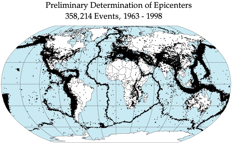
The Cascades extend from Lassen Peak (also known as Mount Lassen) (3170 m) in northern California to Lytton Mountain (2,049 m) in Canada, just southeast of the confluence of the Fraser and Thompson Rivers. The tallest volcanoes of the Cascades are called the High Cascades and dominate their surroundings, often standing twice the height of the nearby mountains. They often have a visual height (height above nearby crestlines) of one mile (1.6 km) or more. The tallest peaks, such as the 14,411 foot (4,395 m) high Mount Rainier, dominate their surroundings for 50 to 100 miles (80 to 160 km).The northern part of the range, north of Mount Rainier, is known as the North Cascades in the United States but is formally named the Cascade Mountains north of the Canada – United States border, reaching to the northern extremity of the Cascades at Lytton Mountain. Overall, the North Cascades and southwestern Canadian Cascades are extremely rugged, with many of the lesser peaks steep and glaciated, with valleys quite low relative to its peaks and ridges, resulting in great local relief, and major passes are only about 1,000 m (3,300 ft) high. The southern part of the Canadian Cascades, particularly the Skagit Range, are geologically and topographically similar to the North Cascades, while the northern and northeastern parts – the Coquihalla Range, the name of which is unofficial,[citation needed], the northern half of the Hozameen Range and most of the Okanagan Range are less glaciated and more plateau-like in character, resembling nearby areas of the Thompson Plateau.
Because of the range’s proximity to the Pacific Ocean, precipitation is substantial, especially on the western slopes, with annual accumulations of up to 150 inches (3,800 mm) in some areas—Mount Baker, for instance, recorded the largest single-season snowfall on record in the world in 1999—and heavy snowfall as low as 2,000 feet (600 m). It is not uncommon for some places in the Cascades to have over 200 inches (5,500 mm) of snow accumulation, such as at Lake Helen (near Lassen Peak), one of the snowiest places in the world. Most of the High Cascades are therefore white with snow and ice year-round. The western slopes are densely covered with Douglas-fir, Western Hemlock and Red alder, while the drier eastern slopes are mostly Ponderosa Pine, with Western Larch at higher elevations. Annual rainfall drops to 9 inches (200 mm) on the eastern foothills due to a rainshadow effect.
Beyond the foothills is an arid plateau that was created 16 million years ago as a coalescing series of layered flood basalt flows. Together, these sequences of fluid volcanic rock form a 200,000 square mile (520,000 km2) region out of eastern Washington, Oregon, and parts of Northern California and Idaho called the Columbia River Plateau.
The Columbia River Gorge is the only major break in the American part of the Cascades. When the Cascades started to rise 7 million years ago in the Pliocene, the Columbia River drained the relatively low Columbia River Plateau. As the range grew, the Columbia was able to keep pace, creating the gorge and major pass seen today. The gorge also exposes uplifted and warped layers of basalt from the plateau.
North Cascades
- Coquihalla Mountain (southern British Columbia) — highest peak in the Bedded Range.
- Mount Baker (Near the United States–Canada border) — highest peak in northern Washington. It is an active volcano[5]. Steam activity from its crater occurs relatively frequently. Mount Baker is one of the snowiest places on Earth; in 1999 the ski area (on a subsidiary peak) recorded the world’s greatest single-season snowfall: 1,140 inches (95 feet or 2,896 cm).
- Glacier Peak (northern Washington) — secluded and relatively inaccessible peak. Contrary to its name, its glacial cover isn’t that extensive. The volcano is surprisingly small in volume, and gets most of its height by having grown atop a nonvolcanic ridge.
High Cascades
- Mount Rainier (southeast of Tacoma, Washington) — highest peak in the Cascades, it dominates the surrounding landscape. There is no other higher peak northward until the Yukon-Alaska-BC border apex beyond the Alsek River.
- Mount St. Helens (southern Washington) — Erupted in 1980, leveling forests to the north of the mountain and sending ash across the northwest. The northern part of the mountain was destroyed in the blast (1980 Mount St. Helens eruption).
- Mount Adams (east of Mount St. Helens) — the second highest peak in Washington and third highest in the Cascade Range.
- Mount Hood (northern Oregon) — the highest peak in Oregon and arguably the most frequently climbed major peak in the Cascades.
- Mount Jefferson (northcentral Oregon) — the second highest peak in Oregon.
- Three Fingered Jack (northcentral Oregon) — Highly eroded Pleistocene volcano.
- Mount Washington (between Santiam and McKenzie passes) — a highly eroded shield volcano. [2]
- Three Sisters (near the city of Bend, Oregon) — South Sister is the highest and youngest, with a well defined crater. Middle Sister is more pyramidal and eroded. North Sister is the oldest and has a crumbling rock pinnacle.
- Broken Top (to the southeast of South Sister) — a highly eroded extinct stratovolcano. Contains Bend Glacier.
- Newberry Volcano — isolated caldera with two crater lakes. Very variable lavas. Flows from here have reached the city of Bend.
- Mount Bachelor (near Three Sisters) — a geologically young (less than 15,000 years) shield-to-stratovolcano which is now the site of a popular ski resort. (Mt. Bachelor ski area)
- Diamond Peak (south of Willamette Pass) — a 8,744 feet (2,665 m) volcano composed of 15 cubic kilometres (3.6 cu mi) of basaltic andesite.
- Mount Bailey (north of Mount Mazama)
- Mount Thielsen (east of Mount Bailey) — highly eroded volcano with a prominent spire, making it the Lightning Rod of the Cascades.
- Mount Mazama (southern Oregon) — better known for its Crater Lake, which is a caldera formed by a catastrophic eruption which took out most of the summit roughly 6,900 years ago. Mount Mazama is estimated to have been about 11,000 ft. (3,350 m) elevation prior to the blast.
- Mount Scott (southern Oregon) — on the southeastern flank of Crater Lake. At 8,929 feet (2,721 m) elevation, this small stratovolcano is the highest peak in Crater Lake National Park.
- Mount McLoughlin (near Klamath Falls, Oregon) — presents a symmetrical appearance when viewed from Klamath Lake.
- Medicine Lake Volcano — a shield volcano in northern California which is the largest volcano by volume in the Cascades.
- Mount Shasta (northern California) — second highest peak in the Cascades. Can be seen in the Sacramento Valley as far as 140 miles (225 km) away, as it is a dominating feature of the region.
- Lassen Peak (south of Mount Shasta) — southernmost volcano in the Cascades and the most easily climbed peak in the Cascades. It erupted from 1914 to 1921, and like Mount Shasta, it too can be seen in the Sacramento Valley, up to 120 miles (193 km) away. Lowest Peak because the Cascades extend from it.